


Offered by:
Timeless Intaglio – Rare Prints, Maps & Books
By Appt.
Alamo, CA 94507 , United States
Call Seller
925.272.8170
Showrooms
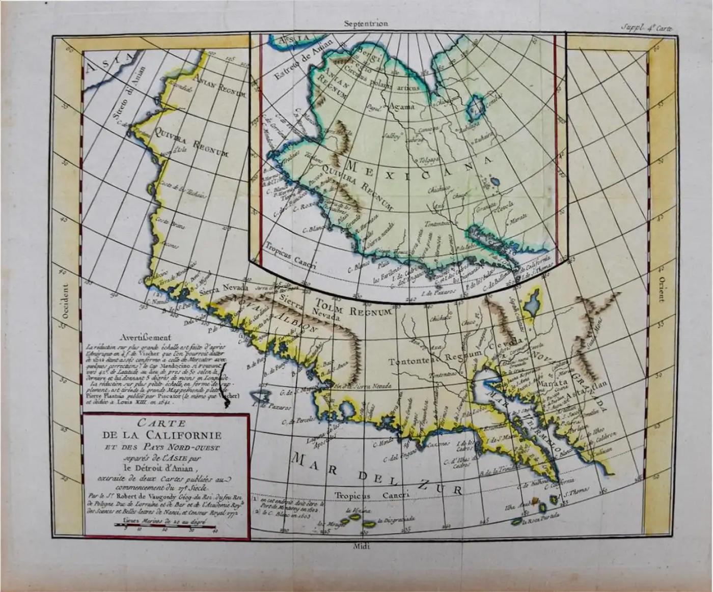
California: 18th Century Hand-colored Map by de Vaugondy
-
Description
This is an 18th century hand-colored map of the western portions of North America entitled "Carte de la Californie et des Pays Nord-Ouest separés de l'Asie par le détroit d'Anian, extraite de deux cartes publiees au commencement de 17e Siecle" (Map of California and the Northwestern Countries separated from Asia by the Anian Strait, from two maps published at the beginning of the 17th century), created by Didier Robert De Vaugondy and published in Paris in 1772 in Diderot's Encyclopedie. The map and its inset are based on earlier maps from 1612 by and 1641 by the Dutch cartographers Petrus Plancius (1552-1622) and Nicolaes Visscher I (1618- 1679) relying on information included on maps by Gerardus Mercator (1512-1594).
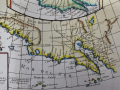
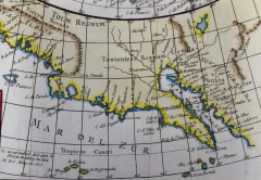
The main portions of the map depicts the west coast of North America from Present day Alaska in the north to Baja California in the south. The map includes the Strait of Anian in the region of Alaska, which refers to the legendary but nonexistent Northwest Passage, hoped to be a link between the Atlantic and Pacific oceans and a desirable trade route from Europe to North America. Captain James Cook eventually disproved its existence during his third and final voyage in 1778.
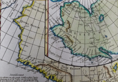
A large inset map of the same region curiously depicts the coastline differently than in the larger portion of the map. The larger map shows Mendocino in Northern California, the Bay of San Miguel (present day San Diego) and Cabo de California (Cabo San Lucas) at the southern tip of Baja California, while the smaller inset map includes C. de San Francisco and los Farilones (the Farallon Islands) and Isle De Paxaros, possibly representing Catalina Island. The larger map shows Nova Albion, the name given to Northern California by Sir Francis Drake when he claimed the area for England in 1579. His point of landfall is now called Drake's Cove, which is part of Point Reyes National Seashore. The smaller inset map identifies the entire region as "Mexicana".
These maps are based on maps by Vischer of 1612 and 1641, and appeared in the Supplement to Denis Diderot's Encyclopedie. Both maps showing the fictitious Strait of Anian at the top; it was part of the legendary Northwest Passage, the long hoped for link of the Pacific and Atlantic Oceans, whose existence many explorers attempted to prove, and which The smaller inset map shows much more of the Strait, along with an open sea, making a suggestion of a Northwest Passage. The coastlines vary in both maps, with the smaller one listing important place names such as . Image sie: 12 3/4 x 12". Paper size: 18 1/2 x 15 1/4".
The map is printed on watermarked laid, chain-linked paper with wide margins. The sheet measures 13.75" high x 16.63" wide. The are vertical and horizontal fold, as issued, with reinforcement of a left vertical fold on the verso. There is minimal discoloration of the edges of the left and lower margins and a few faint spots on the right, but the map is otherwise in excellent condition.
Didier Robert de Vaugondy (1723-1786) was the son of Gilles Robert de Vaugondy, who was a prominent French cartographer, printmaker and publisher. The two worked together in the family business, they publishing atlases. The best know publication was the Atlas Universel (1757). Didier followed his father as the royal cartographer/hydrographer to King Louis XV of France. He held a similar position in the court of the Duke of Lorraine and King of Poland. He later became the royal censor for information published in French geography texts, sea charts and publication describing travel and exploration. -
More Information
Documentation: Signed Period: Pre 18th Century Condition: Good. Creation Date: 1772 Styles / Movements: Americana, Traditional Incollect Reference #: 573233 -
Dimensions
W. 16.63 in; H. 13.75 in; W. 42.24 cm; H. 34.93 cm;
Message from Seller:
Timeless Intaglio is an online gallery of rare and collectable antiquarian prints, maps and books. Although we specialize in all forms of vintage printed works on paper, the majority were created with the intaglio method of transferring ink from a plate, usually copper, to paper with a technique utilizing pressure generated by a press. Email us directly: rbreiman@timelessintaglio.com
More Listings from Timeless Intaglio – Rare Prints, Maps & Books View all 637 listings
-
American Avocet: An 19th Century Audubon Hand-colored Bird Lithograph

-
Natural History of Moths and a Beetle: A Hand-colored Engraving by Moses Harris

-
Admirable Butterflies, Magpie Moths: A Hand-colored Engraving by Moses Harris

-
Yellow-breasted Rail: An Original 19th C. Audubon Hand-colored Bird Lithograph

-
Asparagus: An 18th Century Hand-colored Botanical Engraving by J. Weinmann

-
Apple: An 18th Century Hand-colored Botanical Engraving by J. Weinmann

-
Peacock Butterfly & Moth: A 1st Ed. Hand-colored 18th C. Engraving by M. Harris

-
Butterflies & Moths: A 1st Ed. Hand-colored 18th C. Engraving by M. Harris

-
Tortoise-shell Butterfly, Hawk Moth: Antique Hand-colored Engraving by M. Harris

-
Butterflies & Moths: An Antique Hand-colored Engraving by Moses Harris

-
Horned Grebe: An Original 19th C. Audubon Hand-colored Bird Lithograph

-
Cotton Plant: An 18th Century Hand-colored Botanical Engraving by J. Weinmann

-
Wilson's Plover: An Original 19th C. Audubon Hand-colored Bird Lithograph

-
The Natural History of Moths: An Antique Hand-colored Engraving by Moses Harris

