


Offered by:
Timeless Intaglio – Rare Prints, Maps & Books
By Appt.
Alamo, CA 94507 , United States
Call Seller
925.272.8170
Showrooms
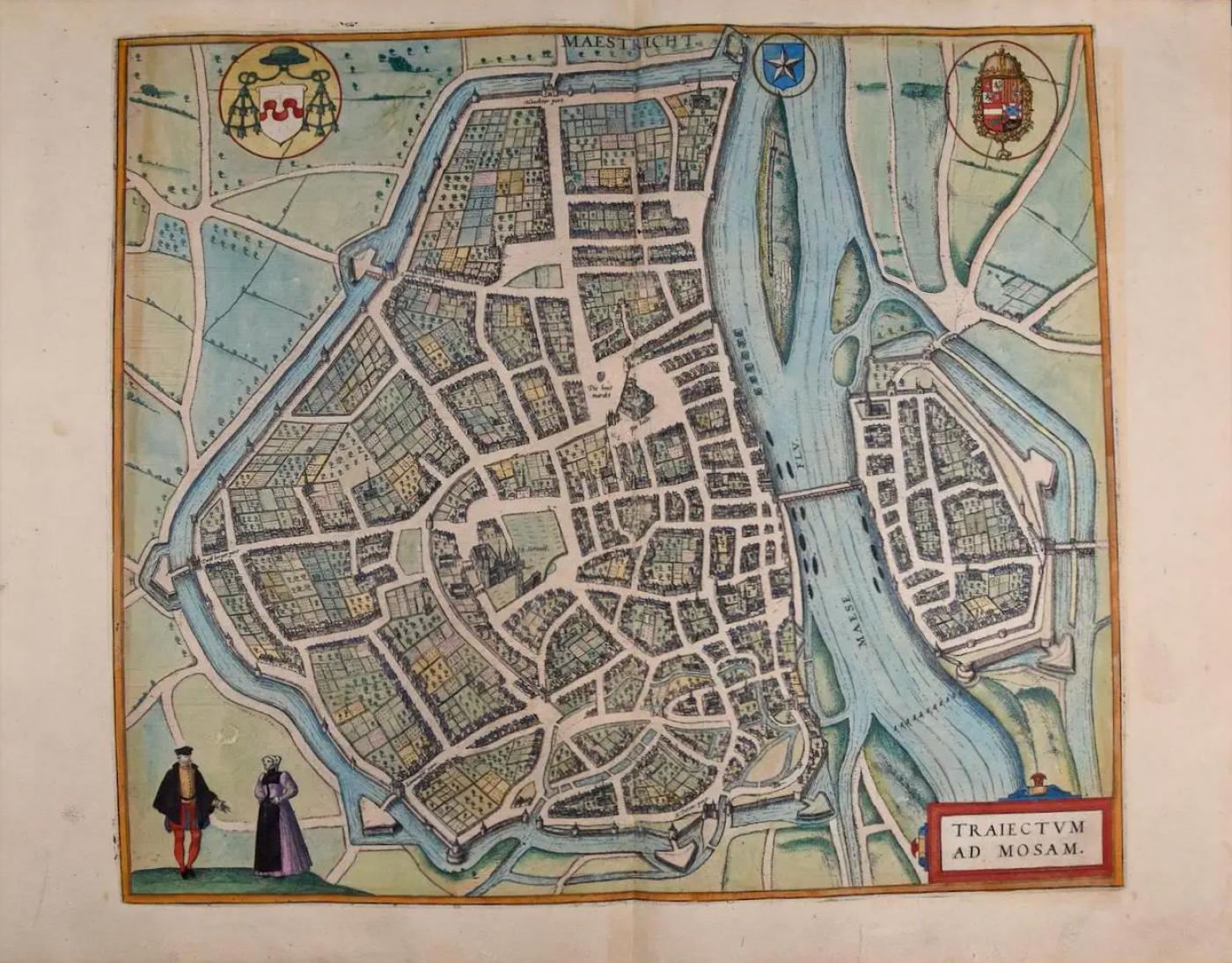
Maastricht, Netherlands: A 16th Century Hand-colored Map by Braun & Hogenberg
-
Description
This is a 16th century original hand-colored copperplate engraved map of Maastricht, Netherlands entitled "Maestricht, Traiectum Ad Mosam" (Translation of Latin: I crossed the bridge) by Georg Braun & Franz Hogenberg, from their famous city atlas "Civitates Orbis Terrarum", published in Cologne, Germany in 1595.
The map depicts a view of Maastricht in a topographically accurate bird's-eye view from the south. Vrijthof Square is in the center of the city with its prominent complex of Sint-Servaas (S. Seraues), with the adjacent church of Sint-Jan. There is a river, labelled Maese Fav. (Meuse River) and an elongated island east of the city and a water-filled moat to the north, south and west. Farmland surrounds the city. A man and a woman are depicted standing on a hill in the lower left apparently in conversation. A coat-of-arms is in the right upper corner and another in the left upper corner. A title cartouche is in the lower right. In 1579, four years after the map was published, the city was sacked by the Spanish under the Duke of Parma, and was held until 1632.
The following is an English translation of an excerpt from the French description of the city on the back of the map: "Turning proudly to our age, our founder and the name of our patron saint, we must point out that we were founded around the year 78 BC and that we owe our origins to Julius Caesar and our name [Lat. Traiectum ad Mosam, "Crossing over the Meuse"] to the fact that the River Meuse can be crossed here [...] and that we also owe much to St Servatus, the first to hold the office of bishop in this city."
References: Van der Krogt 4, #2534; Fauser, #8218; Taschen, Br. Hog., p.223.
This striking hand-colored city view is printed on laid, chain-linked paper with wide margins. The sheet measures 15.75" high by 21" wide. There is a central vertical fold as issued and French text on the verso, with Latin on the front. There is very mild discoloration and smudging in the margins. There are two sort repaired tears at the edge of the sheet. The map is otherwise in very good to excellent condition.
Braun and Hogenberg's 'The Civitates Orbis Terrarum' was the second atlas of maps ever published and the first atlas of cities and towns of the world. It is one of the most important books published in the 16th century. Most of the maps in the atlas were engraved by Franz Hogenberg and the text, with its descriptions of the history and additional factual information of the cities, was written by a team of writers and edited by Georg Braun. The work contained 546 bird-eye views and map views of cities and towns from all over the world. It gave graphic representation of the main features of the illustrated cities and towns, including the buildings and streets. Although the ordinary buildings are stylized, the principal buildings are reproduced from actual drawings created on location. The principal landmarks and streets can still be recognized today. In addition, the maps often include the heraldic arms of the city, the nature of the surrounding countryside, the important rivers, streams and harbors, even depicting stone bridges, wooden pontoons, flat-bottomed ferries, ships and working boats, wharves and jetties, as well as land-based activities, including horsemen, pedestrians, wagons, coaches, and palanquins. Small vignettes are often included which illustrate the trade, occupations and habits of the local inhabitants, such as agriculture, paper-making and textiles, as well as local forms of punishment, such as gibbets, wheels, floggings etc. Large figures dressed in their local costume are often presented out of proportion in the foreground. The aim of the authors was to give as much information as possible in a pleasing visual form. They succeeded in creating maps that were both informative and decorative works of art. The atlas is a wonderful glimpse of life in medieval Europe.
Georg Braun (1541-1622) was German Catholic cleric who was born and who died in Cologne, Germany. He was the principal editor of 'The Civitates Orbis Terrarum', acquiring the tables, hiring the artists, and composing the texts. Abraham Ortelius, whose Theatrum Orbis Terrarum of 1570 was the first atlas of maps ever published, assisted Braun in his compilation of the details and maps for the atlas. The Civitates was intended as a companion for the Ortellius' Theatrum, as suggested by the similarity in the titles. Braun was the only survivor of the original team to live to see the publication of last volume (VI) in 1617.
Franz Hogenberg (1535-1590) was a Flemish and German painter, engraver, and mapmaker. He was born in Mechelen (also known as Malines) in Flanders, the son of an engraver. After being expelled from Antwerp by the Duke of Alva, he moved to London and then eventually to Cologne, Germany, where he met Georg Braun and Abraham Ortellius. He engraved most of the plates for Ortelius's Theatrum and the majority of those in the Civitates. Many believe that he was responsible for originating the Civitates project.
Over a hundred of different artists and cartographers, the most significant of whom was Antwerp artist Georg (Joris) Hoefnagel (1542-1600), engraved the copper-plates of the Civitates from drawings. He not only contributed most of the original material for the Spanish and Italian towns but also reworked and modified those of other contributors. After Hoefnagel's death his son Jakob continued the work for the Civitates. -
More Information
Documentation: Signed Period: Pre 18th Century Condition: Good. Styles / Movements: Traditional Incollect Reference #: 602478 -
Dimensions
W. 21 in; H. 15.75 in; W. 53.34 cm; H. 40.01 cm;
Message from Seller:
Timeless Intaglio is an online gallery of rare and collectable antiquarian prints, maps and books. Although we specialize in all forms of vintage printed works on paper, the majority were created with the intaglio method of transferring ink from a plate, usually copper, to paper with a technique utilizing pressure generated by a press. Email us directly: rbreiman@timelessintaglio.com
More Listings from Timeless Intaglio – Rare Prints, Maps & Books View all 637 listings
-
American Coot: An Original 19th C. Audubon Hand-colored Bird Lithograph

-
Cotton Plant: An 18th Century Hand-colored Botanical Engraving by J. Weinmann

-
Admirable Butterflies, Magpie Moths: A Hand-colored Engraving by Moses Harris

-
Wilson's Plover: An Original 19th C. Audubon Hand-colored Bird Lithograph

-
Butterflies & Moths: An Antique Hand-colored Engraving by Moses Harris

-
The Natural History of Moths: An Antique Hand-colored Engraving by Moses Harris

-
Butterflies & Moths: A 1st Ed. Hand-colored 18th C. Engraving by M. Harris

-
Peacock Butterfly & Moth: A 1st Ed. Hand-colored 18th C. Engraving by M. Harris

-
Horned Grebe: An Original 19th C. Audubon Hand-colored Bird Lithograph

-
American Avocet: An 19th Century Audubon Hand-colored Bird Lithograph

-
Apple: An 18th Century Hand-colored Botanical Engraving by J. Weinmann

-
Asparagus: An 18th Century Hand-colored Botanical Engraving by J. Weinmann

-
Tortoise-shell Butterfly, Hawk Moth: Antique Hand-colored Engraving by M. Harris

-
Yellow-breasted Rail: An Original 19th C. Audubon Hand-colored Bird Lithograph

