


Offered by:
Timeless Intaglio – Rare Prints, Maps & Books
By Appt.
Alamo, CA 94507 , United States
Call Seller
925.272.8170
Showrooms
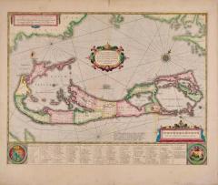
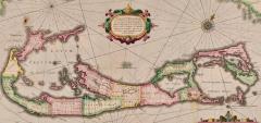
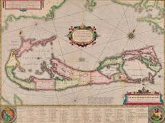
Bermuda: An Early 17th Century Hand-colored Map by Henricus Hondius
-
Description
This attractive and interesting map of Bermuda by Henricus Hondius in 1633 is entitled "Mappa Aestivarum Insularum, Alias Barmudas". It is based on a survey of Richard Norwood in 1618, which led to earlier maps by John Speed in 1627. Henricus's older brother, Jodocus Hondius II, engraved a version of the map for the family firm, but had sold the copper plates of several maps to Willem Blaeu, who used them as the core of his new atlas in 1630, forcing Henricus to engrave another. version A later state has Hondius's name removed and replaced with that of Johannes Jansson.
Henricus Hondius' 1633 map of Bermuda, entitled "Mappa Aestivarum Insularum, Alias Barmudas," is a beautiful and historically significant map that depicts the islands of Bermuda. The map is oriented with north to the right, which was a common orientation for maps of this time period. Overall, Henricus Hondius' 1633 map of Bermuda is a stunning example of cartography from the seventeenth century. Its detailed depiction of the islands of Bermuda and its illustrations of ships and sea creatures make it a fascinating historical artifact.
Bermuda was discovered by the Spaniard Juan de Bermudez in 1515, and is named for him. The first settlers of Bermuda resulted from an expedition of Virginia colonists led by Sir George Somers in 1609. His ship, the ‘Sea Venture’ was wrecked off the coast of Bermuda in 1609. The surviving Englishmen divided the island into Tribes and lots (later Parishes). The Latin title of this map, "Aestivarum Insularum" means summers (or Somers) Islands. The experience of Somers and his men inspired William Shakespeare, who dispatched Ariel to "fetch dew from the still-vext Bermoothes" and populated the islands with the cast of The Tempest. The Bermudas were granted to the Virginia Company, which is referenced on the map. The distance to the company's headquarters in Roanoke Colony in Virginia is shown on the map. In 1610, the Virginia Company, in a True Declaration of the Estate of the Colonie of Virginia, said of Bermuda: "These Islands of Bermudos, have evere beene accounted as an inchaunted pile of rocks, and a desert inhabitation for Divels; but all the Faities of the rockes were but flocks of Birds, and all the Divels that haunted the woods, were but heards of Swine".
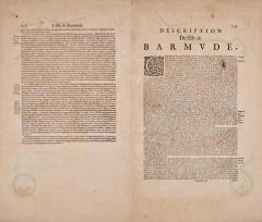
Bermuda is superimposed over a map of the Atlantic with the coastlines of Britain, North America and Hispaniola to demonstrate the relative location of the island. The miniature map below the carouche in the upper left with its own scale, shows the island’s position relative to Cape Cod, Nova Scotia and the Virginian coast. The map vividly illustrates how hazardous the coastline of Bermuda was and still is to shipping by the almost unbroken ring of crosses signifying wrecks surrounding the island. The map is embellished with a striking decorative cartouche centrally, a beautiful compass rose, numerous rhumb lines, a coat-of-arms in the lower left and a vignette in the lower right presumably depicting the wreck of the 'Sea Venture'. The table at the bottom includes a list of the original English "proprietors" the location of the "Tribes" and lots and the number of shares purchased by each proprietor, along with a number key, identifying the land owned by each of the shareholders. French text is present on the verso. There is a beautiful compass rose in the upper right, as well as two other compass roses, with multiple rhumb lines. A vignette in the lower left corner contains a coat-of-arms and another in the lower right corner contains an image of a ship running aground against a large rock formation, representing the shipwreck in 1609 leading to the Virginia colonists populating the island.
This striking and historically significant map of Bermuda is printed on laid chain-linked paper with wide margins. The sheet measures 19" high and 22.38" wide. It has a vertical center fold, as issued. There is mild irregularity of the lower edge and three short lower edge tears and another of the right edge that are expertly reinforced on the verso. There is a spot in the left upper map and a very small faint spot to the left of the title cartouche, as well as a few tiny spots in margins. The map is otherwise in very good condition, considering its almost 400 year age and the thinnest of its paper.
Henricus Hondius (1597-1651) was a Dutch cartographer and publisher, known for his contributions to the field of geography during the Golden Age of Dutch cartography. He was the son of famous cartographer Jodocus Hondius and brother of another renowned cartographer, Johannes Hondius. Henricus began his career as an engraver and worked alongside his father on various projects, including the publication of the famous Mercator-Hondius atlas. After his father's death, he took over the family business and continued to produce and publish maps, atlases, and globes. Henricus is particularly known for his work on the publication of the Atlas Novus, a multi-volume atlas that was published in various editions throughout the 17th century. He also produced maps for other publications, including a 1633 edition of Gerard Mercator's Atlas Minor. In addition to his cartographic work, Henricus was also involved in politics and served as a member of the Amsterdam city council. He died in Amsterdam in 1651, leaving behind a legacy as one of the most important cartographers of his time. -
More Information
Documentation: Documented elsewhere (similar item) Period: Pre 18th Century Condition: Good. Creation Date: 1633 Styles / Movements: Traditional Incollect Reference #: 629502 -
Dimensions
W. 22.38 in; H. 19 in; W. 56.85 cm; H. 48.26 cm;
Message from Seller:
Timeless Intaglio is an online gallery of rare and collectable antiquarian prints, maps and books. Although we specialize in all forms of vintage printed works on paper, the majority were created with the intaglio method of transferring ink from a plate, usually copper, to paper with a technique utilizing pressure generated by a press. Email us directly: rbreiman@timelessintaglio.com
More Listings from Timeless Intaglio – Rare Prints, Maps & Books View all 637 listings
-
American Coot: An Original 19th C. Audubon Hand-colored Bird Lithograph

-
Asparagus: An 18th Century Hand-colored Botanical Engraving by J. Weinmann

-
Wilson's Plover: An Original 19th C. Audubon Hand-colored Bird Lithograph

-
The Natural History of Moths: An Antique Hand-colored Engraving by Moses Harris

-
Horned Grebe: An Original 19th C. Audubon Hand-colored Bird Lithograph

-
Butterflies & Moths: A 1st Ed. Hand-colored 18th C. Engraving by M. Harris

-
Apple: An 18th Century Hand-colored Botanical Engraving by J. Weinmann

-
Admirable Butterflies, Magpie Moths: A Hand-colored Engraving by Moses Harris

-
Yellow-breasted Rail: An Original 19th C. Audubon Hand-colored Bird Lithograph

-
Natural History of Moths and a Beetle: A Hand-colored Engraving by Moses Harris

-
Peacock Butterfly & Moth: A 1st Ed. Hand-colored 18th C. Engraving by M. Harris

-
Butterflies & Moths: An Antique Hand-colored Engraving by Moses Harris

-
Cotton Plant: An 18th Century Hand-colored Botanical Engraving by J. Weinmann

-
American Avocet: An 19th Century Audubon Hand-colored Bird Lithograph

