


Offered by:
Timeless Intaglio – Rare Prints, Maps & Books
By Appt.
Alamo, CA 94507 , United States
Call Seller
925.272.8170
Showrooms
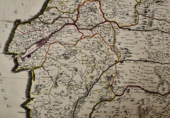
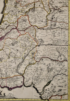
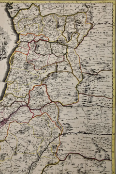
Portugal: A Large 17th Century Hand-colored Map by Sanson and Jaillot
-
Description
This large hand-colored map entitled "Le Royaume de Portugal et des Algarves Divisee en see Archeveches, Eveches et Territoires Par le Sr Sanson" was originally created by Nicholas Sanson d'Abbeville and published by Hubert Jaillot in "Atlas Nouveau" in Paris in 1695. It depicts Portugal, including at the time a separate kingdom of Algarve, and a portion of western Spain. Lisbon and Porto are shown along the west coast of Portugal and Seville in southwestern Spain, along with the Douro River and many other landmarks. There is an ornate title cartouche in the left upper corner which includes multiple naked infants at the feet of mythical-style gods, one sitting in front of a tall tree. The title plaque is topped by a royal coat-of-arms. In the lower left corner a putti and another mythical style god are holding a royal coat-of-arms while sitting on top of a large pedestal containing a scale cartouche.
The map consists of two sheets joined as one along a horizontal joint. The map has original hand-coloring and it is printed on antique hand-made laid, chain-linked paper with wide margins. The sheet measures 38" high and 24.88" wide. There are occasional tiny spots and minimal color offset resulting from contact with the color on the opposite sides of the map over hundreds of years in the atlas. The map is otherwise in very good to excellent condition.
Nicholas Sanson d'Abbeville (1600-1667) was one of the greatest French cartographather of French cartography. Sanson opened his first printing business in Paris in 1638. The king recognized his skill and knowledge and made him the official geographer to the court. He eventually served two kings in this capacity. Sanson was succeeded by his sons and son-in-law in the business and as geographers to the king. In 1692 his plates were purchased by the prominent Parisian cartographer Alexis Hubert Jaillot (1632-1712), who continued to publish his maps and atlases with a dual Sanson and Jaillot attribution. Jaillot went on to serve King Louis XIV. -
More Information
Documentation: Signed Origin: France Period: Pre 18th Century Condition: Good. Creation Date: 1695 Styles / Movements: Traditional Incollect Reference #: 580951 -
Dimensions
W. 38 in; H. 24.88 in; D. 0.13 in; W. 96.52 cm; H. 63.2 cm; D. 0.33 cm;
Message from Seller:
Timeless Intaglio is an online gallery of rare and collectable antiquarian prints, maps and books. Although we specialize in all forms of vintage printed works on paper, the majority were created with the intaglio method of transferring ink from a plate, usually copper, to paper with a technique utilizing pressure generated by a press. Email us directly: rbreiman@timelessintaglio.com
More Listings from Timeless Intaglio – Rare Prints, Maps & Books View all 637 listings
-
Wilson's Plover: An Original 19th C. Audubon Hand-colored Bird Lithograph

-
Butterflies & Moths: An Antique Hand-colored Engraving by Moses Harris

-
Natural History of Moths and a Beetle: A Hand-colored Engraving by Moses Harris

-
The Natural History of Moths: An Antique Hand-colored Engraving by Moses Harris

-
American Avocet: An 19th Century Audubon Hand-colored Bird Lithograph

-
Tortoise-shell Butterfly, Hawk Moth: Antique Hand-colored Engraving by M. Harris

-
Yellow-breasted Rail: An Original 19th C. Audubon Hand-colored Bird Lithograph

-
Horned Grebe: An Original 19th C. Audubon Hand-colored Bird Lithograph

-
Cotton Plant: An 18th Century Hand-colored Botanical Engraving by J. Weinmann

-
American Coot: An Original 19th C. Audubon Hand-colored Bird Lithograph

-
Peacock Butterfly & Moth: A 1st Ed. Hand-colored 18th C. Engraving by M. Harris

-
Apple: An 18th Century Hand-colored Botanical Engraving by J. Weinmann

-
Butterflies & Moths: A 1st Ed. Hand-colored 18th C. Engraving by M. Harris

-
Asparagus: An 18th Century Hand-colored Botanical Engraving by J. Weinmann

