


Offered by:
Timeless Intaglio – Rare Prints, Maps & Books
By Appt.
Alamo, CA 94507 , United States
Call Seller
925.272.8170
Showrooms
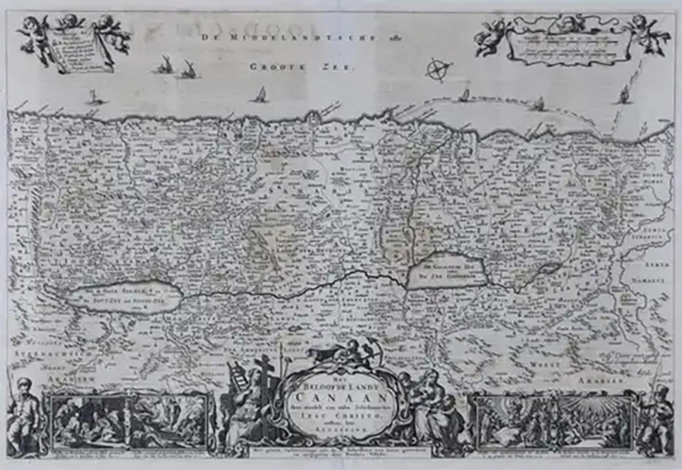
The Holy Land at the Time of Jesus: A 17th Century Dutch Map by Visscher
-
Description
This detailed Dutch map entitled "Het Beloofe de Landt Canaan door wandelt van onsen Salichmaecker Iesu Christo, nessens syne Apostelen" by Nicolaes Visscher was published in Amsterdam in 1663. The map depicts the Holy Land from the Mediterranean Sea to just beyond the Jordan River as it appeared at the time of Jesus. It has an orientation to the west with north to the right and presents details of the cities, towns, rivers, roads, and holy sites associated with the Apostles. The elaborate title cartouche is encircled on three sides by religious figures, which are in turn flanked by two engraved vignettes of New Testament scenes depicting the life of Jesus and a fishermen in each lower corner. Cherubs hold cartouches in the form of banners in the each upper corner. Seven ships sail the Mediterranean (Groote Zee) in the upper portions of the map. Three of these ships trace the voyage of the Apostle Paul.
The map is presented in an ornate brown wood frame embellished by gold-colored leaves and gold inner trim with a double mat; the outer mat is cream-colored and the inner mat is black. There is a central fold, as issued. There is some text offset from the text on the verso and scattered areas of focal discoloration. The map is otherwise in excellent condition.
Another map of the "Holy Land" (a city view of Jaffa (Tel Aviv) as it appeared in 1668 by Sanson) with an identical style frame and mat is available. This pair of maps would make a wonderful display grouping. Please see Reference #LU5206220653472. A discount is available for purchase of the pair of maps.
The Visscher family were one of the great cartographic families of the 17th century. Begun by Claes Jansz Visscher (1587-1652) and continued by his son Nicolaes (1618-1679), grandson Nicolaes II (1649-1702) and then by his grandson’s widow, Elizabeth until her death in 1726. The Visschers were prolific publishers, producing individual maps and also atlases made up to their customers’ specifications. They are commonly regarded as second only to the Blaeu family, among Dutch mapmakers, for the high quality of engraving and decoration, and the geographical accuracy of their many maps. -
More Information
Documentation: Signed Origin: Netherlands Period: 18th Century Materials: Paper Condition: Good. Wear consistent with age and use. Styles / Movements: Traditional Incollect Reference #: 571688 -
Dimensions
W. 28.5 in; H. 22.75 in; D. 1.13 in; W. 72.39 cm; H. 57.79 cm; D. 2.87 cm;
Message from Seller:
Timeless Intaglio is an online gallery of rare and collectable antiquarian prints, maps and books. Although we specialize in all forms of vintage printed works on paper, the majority were created with the intaglio method of transferring ink from a plate, usually copper, to paper with a technique utilizing pressure generated by a press. Email us directly: rbreiman@timelessintaglio.com
More Listings from Timeless Intaglio – Rare Prints, Maps & Books View all 637 listings
-
Butterflies & Moths: An Antique Hand-colored Engraving by Moses Harris

-
Asparagus: An 18th Century Hand-colored Botanical Engraving by J. Weinmann

-
American Coot: An Original 19th C. Audubon Hand-colored Bird Lithograph

-
Apple: An 18th Century Hand-colored Botanical Engraving by J. Weinmann

-
The Natural History of Moths: An Antique Hand-colored Engraving by Moses Harris

-
Yellow-breasted Rail: An Original 19th C. Audubon Hand-colored Bird Lithograph

-
Natural History of Moths and a Beetle: A Hand-colored Engraving by Moses Harris

-
Butterflies & Moths: A 1st Ed. Hand-colored 18th C. Engraving by M. Harris

-
Peacock Butterfly & Moth: A 1st Ed. Hand-colored 18th C. Engraving by M. Harris

-
Wilson's Plover: An Original 19th C. Audubon Hand-colored Bird Lithograph

-
Admirable Butterflies, Magpie Moths: A Hand-colored Engraving by Moses Harris

-
American Avocet: An 19th Century Audubon Hand-colored Bird Lithograph

-
Horned Grebe: An Original 19th C. Audubon Hand-colored Bird Lithograph

-
Cotton Plant: An 18th Century Hand-colored Botanical Engraving by J. Weinmann

