


Offered by:
Timeless Intaglio – Rare Prints, Maps & Books
By Appt.
Alamo, CA 94507 , United States
Call Seller
925.272.8170
Showrooms
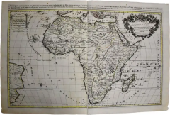
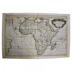
Africa: A Large 17th Century Hand-Colored Map by Sanson and Jaillot
-
Description
This large original hand-colored copperplate engraved map of Africa entitled "L'Afrique divisee suivant l'estendue de ses principales parties ou sont distingues les uns des autres, Les Empires, Monarchies, Royaumes, Estats et Peuples qui partagent aujourd'huy l'Afrique sur les Relations les plus Nouvelles par le Sanson" was originally created by Nicholas Sanson d'Abbeville and published by Hubert Jaillot in "Atlas Nouveau" in Paris in 1692. It depicts the continent of Africa, Madagascar, the Azores, Canaries, and Cape Verde Islands, as well as several islands in the southern Atlantic and a small portion of Southern Europe and northeastern South America, including portions of Brazil and Paraguay. The Barbary Coast of North Africa is depicted in detail, as this area had been thoroughly explored by European and Arab traders. A decorative title cartouche in the right upper corner includes two mythical-style male gods, two native black men, a lion, ostrich, elephant, and alligator. There is a coat-of-arms in the upper center with plants and a scalloped design about the periphery. A scale cartouche is present in the upper left corner.
This large original hand-colored copperplate engraved map of Africa consists of two sheets joined as one along a vertical joint. It is printed on antique hand-made laid, chain-linked paper with wide margins. The sheet measures 24.88" high and 38" wide. There is a central vertical joint, as issued, with mild misregistration and mild irregularity of the lower edges of the left and right margins. There are two small spots in the upper margin, one tiny spot in the right margin and mild color offset resulting from contact with the color on the opposite sides of the map over hundreds of years in the atlas. The map is otherwise in very good to excellent condition.
Nicholas Sanson d'Abbeville (1600-1667) was one of the greatest French cartographather of French cartography. Sanson opened his first printing business in Paris in 1638. The king recognized his skill and knowledge and made him the official geographer to the court. He eventually served two kings in this capacity. Sanson was succeeded by his sons and son-in-law in the business and as geographers to the king. In 1692 his plates were purchased by the prominent Parisian cartographer Alexis Hubert Jaillot (1632-1712), who continued to publish his maps and atlases with a dual Sanson and Jaillot attribution. Jaillot went on to serve King Louis XIV. -
More Information
Documentation: Signed Origin: France Period: Pre 18th Century Condition: Good. Repaired: There are small professionally repaired tears on the verso. Wear consistent with age and use. Creation Date: 1692 Styles / Movements: African, Traditional Incollect Reference #: 580952 -
Dimensions
W. 38 in; H. 24.88 in; D. 0.13 in; W. 96.52 cm; H. 63.2 cm; D. 0.33 cm;
Message from Seller:
Timeless Intaglio is an online gallery of rare and collectable antiquarian prints, maps and books. Although we specialize in all forms of vintage printed works on paper, the majority were created with the intaglio method of transferring ink from a plate, usually copper, to paper with a technique utilizing pressure generated by a press. Email us directly: rbreiman@timelessintaglio.com
More Listings from Timeless Intaglio – Rare Prints, Maps & Books View all 637 listings
-
Butterflies & Moths: An Antique Hand-colored Engraving by Moses Harris

-
Apple: An 18th Century Hand-colored Botanical Engraving by J. Weinmann

-
Admirable Butterflies, Magpie Moths: A Hand-colored Engraving by Moses Harris

-
Tortoise-shell Butterfly, Hawk Moth: Antique Hand-colored Engraving by M. Harris

-
Cotton Plant: An 18th Century Hand-colored Botanical Engraving by J. Weinmann

-
The Natural History of Moths: An Antique Hand-colored Engraving by Moses Harris

-
Horned Grebe: An Original 19th C. Audubon Hand-colored Bird Lithograph

-
Butterflies & Moths: A 1st Ed. Hand-colored 18th C. Engraving by M. Harris

-
Peacock Butterfly & Moth: A 1st Ed. Hand-colored 18th C. Engraving by M. Harris

-
Natural History of Moths and a Beetle: A Hand-colored Engraving by Moses Harris

-
Asparagus: An 18th Century Hand-colored Botanical Engraving by J. Weinmann

-
American Avocet: An 19th Century Audubon Hand-colored Bird Lithograph

-
Wilson's Plover: An Original 19th C. Audubon Hand-colored Bird Lithograph

-
Yellow-breasted Rail: An Original 19th C. Audubon Hand-colored Bird Lithograph

