


Offered by:
Timeless Intaglio – Rare Prints, Maps & Books
By Appt.
Alamo, CA 94507 , United States
Call Seller
925.272.8170
Showrooms
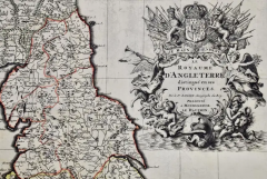
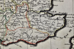
Great Britain, N. France: A Large 17th C. Hand-colored Map by Sanson and Jaillot
-
Description
This large hand-colored 17th century copperplate engraved map entitled "Le Royaume D Angleterre, distingué en ses Provinces. Par le Sr. Sanson. Geographe du Roy. Presenté A Monseigneur Le Dauphin" was originally created by Nicholas Sanson d'Abbeville and published by Hubert Jaillot in "Atlas Nouveau" in Paris in 1693. It depicts England, portions of Scotland, Wales and Ireland, the English Channel and portions of Normandy in northern France. It includes London, Windsor, Oxford, Canterbury, Dover, Calais, Rouen and many other landmarks. There is an elaborate ornate cartouche in the right upper corner that includes the royal coat-of-arms surrounded by flags and spears, female angels, putti blowing horns, a horse, the ocean and a globe.
The map consists of two sheets joined as one along a horizontal joint. The map has original hand-coloring and it is printed on antique hand-made laid, chain-linked paper with wide margins. The sheet measures 38" high and 24.88" wide. There is mild offset resulting from contact with the color on the opposite sides of the map over hundreds of years in the atlas. There is one spot over the English Channel, but the map is otherwise in very good to excellent condition.
Nicholas Sanson d'Abbeville (1600-1667) was one of the greatest French cartographather of French cartography. Sanson opened his first printing business in Paris in 1638. The king recognized his skill and knowledge and made him the official geographer to the court. He eventually served two kings in this capacity. Sanson was succeeded by his sons and son-in-law in the business and as geographers to the king. In 1692 his plates were purchased by the prominent Parisian cartographer Alexis Hubert Jaillot (1632-1712), who continued to publish his maps and atlases with a dual Sanson and Jaillot attribution. Jaillot went on to serve King Louis XIV. -
More Information
Documentation: Signed Period: Pre 18th Century Condition: Good. Creation Date: 1693 Styles / Movements: Traditional Incollect Reference #: 580978 -
Dimensions
W. 24.88 in; H. 38 in; W. 63.2 cm; H. 96.52 cm;
Message from Seller:
Timeless Intaglio is an online gallery of rare and collectable antiquarian prints, maps and books. Although we specialize in all forms of vintage printed works on paper, the majority were created with the intaglio method of transferring ink from a plate, usually copper, to paper with a technique utilizing pressure generated by a press. Email us directly: rbreiman@timelessintaglio.com
More Listings from Timeless Intaglio – Rare Prints, Maps & Books View all 637 listings
-
Apple: An 18th Century Hand-colored Botanical Engraving by J. Weinmann

-
Butterflies & Moths: An Antique Hand-colored Engraving by Moses Harris

-
Admirable Butterflies, Magpie Moths: A Hand-colored Engraving by Moses Harris

-
Yellow-breasted Rail: An Original 19th C. Audubon Hand-colored Bird Lithograph

-
The Natural History of Moths: An Antique Hand-colored Engraving by Moses Harris

-
American Coot: An Original 19th C. Audubon Hand-colored Bird Lithograph

-
Peacock Butterfly & Moth: A 1st Ed. Hand-colored 18th C. Engraving by M. Harris

-
Asparagus: An 18th Century Hand-colored Botanical Engraving by J. Weinmann

-
Horned Grebe: An Original 19th C. Audubon Hand-colored Bird Lithograph

-
Cotton Plant: An 18th Century Hand-colored Botanical Engraving by J. Weinmann

-
Butterflies & Moths: A 1st Ed. Hand-colored 18th C. Engraving by M. Harris

-
Tortoise-shell Butterfly, Hawk Moth: Antique Hand-colored Engraving by M. Harris

-
Wilson's Plover: An Original 19th C. Audubon Hand-colored Bird Lithograph

-
American Avocet: An 19th Century Audubon Hand-colored Bird Lithograph

