


Offered by:
Timeless Intaglio – Rare Prints, Maps & Books
By Appt.
Alamo, CA 94507 , United States
Call Seller
925.272.8170
Showrooms
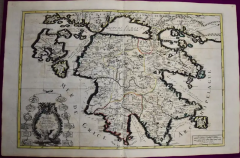
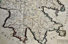
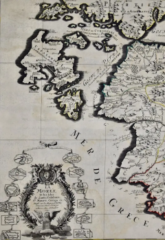
Southern Greece: A Large 17th Century Hand-colored Map By Sanson and Jaillot
-
Description
This large original hand-colored copperplate engraved map of southern Greece and the Pelopponese Peninsula entitled "La Moree Et Les Isles De Zante, Cefalonie, Ste. Marie, Cerigo & C. Dresse Sur Les Memoires Les Plus Nouveaux, Par Le Sr. Sanson" was originally created by Nicholas Sanson d'Abbeville and published by Hubert Jaillot in "Atlas Nouveau" in Paris in 1692. It depicts the Pelopponese Peninsula extending southward from just north of the gulf of Corinth and includes the Ionian islands of Levkada, Kefalonia, Zakinthos and Kythera. A decorative title cartouche in the left lower corner includes a victory wreath of olive branches and topped by a royal coat-of-arms held by two young angels. At the bottom the Lion of Venice sits triumphant above the crescent of the Ottoman Turk, suspended in the clouds. The wreath is surrounded by 12 vignette plans of the ports and castles captured by the Venetians. Moree or Morea was the name of the Peloponnese peninsula in southern Greece during the Middle Ages and the early modern period. The name was used for the Byzantine province known as the Despotate of the Morea, by the Ottoman Empire for the Morea Eyalet, and by the Republic of Venice for the short-lived Kingdom of the Morea.
This large original hand-colored copperplate engraved map of southern Greece and the Pelopponese peninsula consists of two sheets joined as one along a vertical joint. It is printed on antique hand-made laid, chain-linked paper with wide margins. The sheet measures 24.88" high and 38" wide. There is a central vertical joint, as issued. There is a repaired tear in the lower margin to the right of the central vertical fold and mild color offset resulting from contact with the color on the opposite sides of the map over hundreds of years in the atlas. The map is otherwise in very good to excellent condition.
Nicholas Sanson d'Abbeville (1600-1667) was one of the greatest French cartographather of French cartography. Sanson opened his first printing business in Paris in 1638. The king recognized his skill and knowledge and made him the official geographer to the court. He eventually served two kings in this capacity. Sanson was succeeded by his sons and son-in-law in the business and as geographers to the king. In 1692 his plates were purchased by the prominent Parisian cartographer Alexis Hubert Jaillot (1632-1712), who continued to publish his maps and atlases with a dual Sanson and Jaillot attribution. Jaillot went on to serve King Louis XIV. -
More Information
Documentation: Signed Period: Pre 18th Century Condition: Good. Creation Date: 1692 Styles / Movements: Traditional Incollect Reference #: 580980 -
Dimensions
W. 38 in; H. 24.88 in; W. 96.52 cm; H. 63.2 cm;
Message from Seller:
Timeless Intaglio is an online gallery of rare and collectable antiquarian prints, maps and books. Although we specialize in all forms of vintage printed works on paper, the majority were created with the intaglio method of transferring ink from a plate, usually copper, to paper with a technique utilizing pressure generated by a press. Email us directly: rbreiman@timelessintaglio.com
More Listings from Timeless Intaglio – Rare Prints, Maps & Books View all 637 listings
-
Asparagus: An 18th Century Hand-colored Botanical Engraving by J. Weinmann

-
Tortoise-shell Butterfly, Hawk Moth: Antique Hand-colored Engraving by M. Harris

-
Yellow-breasted Rail: An Original 19th C. Audubon Hand-colored Bird Lithograph

-
Natural History of Moths and a Beetle: A Hand-colored Engraving by Moses Harris

-
Apple: An 18th Century Hand-colored Botanical Engraving by J. Weinmann

-
Horned Grebe: An Original 19th C. Audubon Hand-colored Bird Lithograph

-
American Coot: An Original 19th C. Audubon Hand-colored Bird Lithograph

-
Peacock Butterfly & Moth: A 1st Ed. Hand-colored 18th C. Engraving by M. Harris

-
Cotton Plant: An 18th Century Hand-colored Botanical Engraving by J. Weinmann

-
American Avocet: An 19th Century Audubon Hand-colored Bird Lithograph

-
Wilson's Plover: An Original 19th C. Audubon Hand-colored Bird Lithograph

-
Butterflies & Moths: A 1st Ed. Hand-colored 18th C. Engraving by M. Harris

-
The Natural History of Moths: An Antique Hand-colored Engraving by Moses Harris

-
Butterflies & Moths: An Antique Hand-colored Engraving by Moses Harris

