


Offered by:
Timeless Intaglio – Rare Prints, Maps & Books
By Appt.
Alamo, CA 94507 , United States
Call Seller
925.272.8170
Showrooms
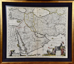
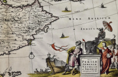
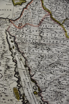
Persia, Armenia & Adjacent Regions: A Hand-colored 17th Century Map by De Wit
-
Description
This colorful and detailed 17th century copperplate map by Frederick De Wit was published in Amsterdam between 1666 and 1690. It depicts the Caspian Sea and portions of the Black, Red, Mediteranen, and Arabian Seas, the Nile River, Turkey, Iran, Iraq, Syria, Israel, Kuwait, Saudi Arabia, Qatar, United Arab Emirates, Armenia, Cypres, Georgia, Turkmenistan, Yemen, Djibouti and portions of Afghanistan, Pakistan, Uzbekistan, Ethiopia, Egypt, Sudan, Eritrea and Somalia, Macedonia and Southern Russia. A colorful title cartouche in the right lower corner depicts a ship in harbor adjacent to a dingy with six men about to board the ship. There are people in native costumes, including Arab, African, possibly Turkish and an elephant riden by an umbrella holding man. The map is embellished with five sailing ships. A cartouche depicting scale in the lower left corner includes a man in Arab garb utilizing a device to measure distance on a map.
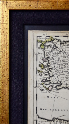
This hand-colored map is presented in an antiqued gold-colored wood frame with an eggplant-colored fabric mat outside of museum clear, anit-glare, UV protected plexiglass. The frame measures 23.5" x 27" x 1.325". There is a central vertical fold as issued, a crease in the lower map to the right of midline and very minimal faint discoloration at the edges of the margins and a few barely visible spots. The map is otherwise in excellent condition.
Frederick De Wit (1629-1706) was an engraver, cartographer and map dealer who ran a prominent and productive printing business in Amsterdam, founded in 1654 and initially called The Three Crabs and later The White Chart. He published his first atlas in 1662. In 1695 he purchased a large collection of the plates of the prestigious Blaeu publishing business. After his death in 1706, his wife Maria continued in the business for four years before selling it at the auction. A majority of the plates were purchased by Pieter Mortier. His thriving and growing business eventually became Covens & Mortier, one of the largest and most successful cartography and printing businesses of the eighteenth century. -
More Information
Period: Pre 18th Century Condition: Good. Creation Date: 1680 Styles / Movements: Middle Eastern, Persian, Traditional Incollect Reference #: 582329 -
Dimensions
W. 27 in; H. 23.5 in; D. 1.325 in; W. 68.58 cm; H. 59.69 cm; D. 3.37 cm;
Message from Seller:
Timeless Intaglio is an online gallery of rare and collectable antiquarian prints, maps and books. Although we specialize in all forms of vintage printed works on paper, the majority were created with the intaglio method of transferring ink from a plate, usually copper, to paper with a technique utilizing pressure generated by a press. Email us directly: rbreiman@timelessintaglio.com
More Listings from Timeless Intaglio – Rare Prints, Maps & Books View all 637 listings
-
Butterflies & Moths: An Antique Hand-colored Engraving by Moses Harris

-
Admirable Butterflies, Magpie Moths: A Hand-colored Engraving by Moses Harris

-
The Natural History of Moths: An Antique Hand-colored Engraving by Moses Harris

-
Yellow-breasted Rail: An Original 19th C. Audubon Hand-colored Bird Lithograph

-
Wilson's Plover: An Original 19th C. Audubon Hand-colored Bird Lithograph

-
Butterflies & Moths: A 1st Ed. Hand-colored 18th C. Engraving by M. Harris

-
American Coot: An Original 19th C. Audubon Hand-colored Bird Lithograph

-
Asparagus: An 18th Century Hand-colored Botanical Engraving by J. Weinmann

-
Tortoise-shell Butterfly, Hawk Moth: Antique Hand-colored Engraving by M. Harris

-
American Avocet: An 19th Century Audubon Hand-colored Bird Lithograph

-
Apple: An 18th Century Hand-colored Botanical Engraving by J. Weinmann

-
Natural History of Moths and a Beetle: A Hand-colored Engraving by Moses Harris

-
Cotton Plant: An 18th Century Hand-colored Botanical Engraving by J. Weinmann

-
Peacock Butterfly & Moth: A 1st Ed. Hand-colored 18th C. Engraving by M. Harris

