


Offered by:
Timeless Intaglio – Rare Prints, Maps & Books
By Appt.
Alamo, CA 94507 , United States
Call Seller
925.272.8170
Showrooms
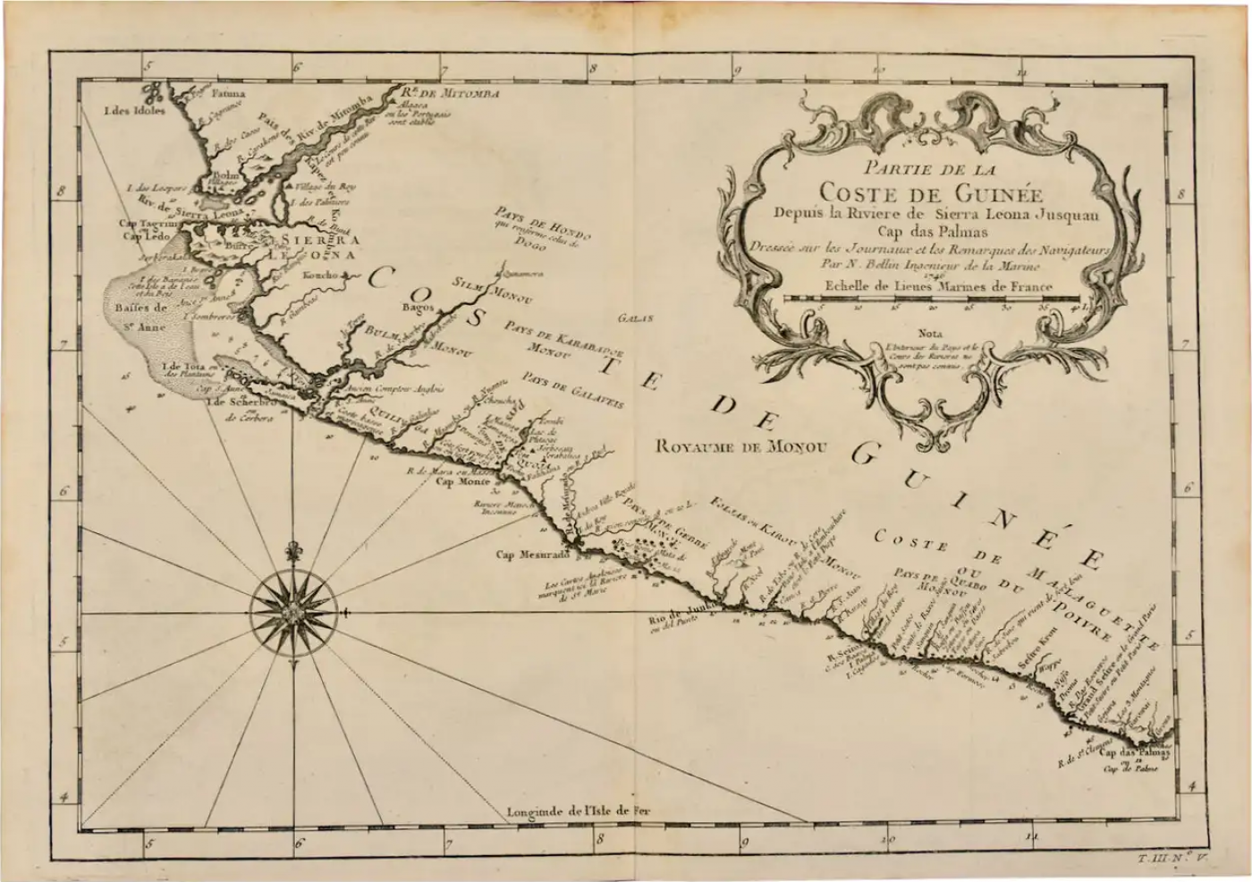
West Coast of Africa, Guinea & Sierra Leone: An 18th Century Map by Bellin
-
Description
Jacques Bellin's copper-plate map entitled "Partie de la Coste de Guinee Dupuis la Riviere de Sierra Leona Jusquau Cap das Palmas", depicting the coast of Guinea and Sierra Leone in West Africa, published in Paris in Antoine-Francois Prevost's "Histoire Générale des Voyages, ou nouvelle collection de toutes les relations de voyages par mer et par terre, qui ont été publiées jusqu'à present dans les différentes langues de toutes les nations connues".
Prevost's "L'Histoire Generale des Voyages" was an expansive work that mapped China, the East Indies, Asia, the Americas, early voyages to Australia, New Guinea, the Palau Islands, Africa, and voyages in the Pacific including those of Magellan, Schouten, and Le Maire, Drake, Sarmiento, Cavendish, Spilbergen, Narborough, Rogers, Cowley, Frazier, and Anson. The work included accounts of the Dutch and French voyages to the East Indies, voyages to China, and the British East India Company's voyages to India and Ceylon. The publication was published before the three voyages of discovery by Captain James Cook later in the 18th century.
The map is printed on laid, chain-linked, watermarked paper. There are wide margins all around and a central vertical fold, as issued. There is mild spotting in the upper margin and to a lesser extent in the right margin, but the map is otherwise in excellent condition.
Two other Bellin maps are available on 1stDibs, including an unframed map of the island of St. Christophe, now known as St. Kitts, "Carte De De l'Isle St. Christophe", Reference #: LU117328585712 and a map of St. Lucie framed in lucite, Reference: LU117324370471. These maps would make a striking display grouping. A discount is available for the purchase of two or more maps.
The map was prepared by Jacques Nicolas Bellin (1703–1772), who was one of the most important cartographers of the 18th century. He served for a number of years as map and chart maker, as well hydrographer to the King of France. -
More Information
Documentation: Signed Origin: France Period: 18th Century Condition: Good. Creation Date: 1746 Styles / Movements: Traditional Incollect Reference #: 582336 -
Dimensions
W. 14.25 in; H. 10 in; D. 0.07 in; W. 36.2 cm; H. 25.4 cm; D. 0.18 cm;
Message from Seller:
Timeless Intaglio is an online gallery of rare and collectable antiquarian prints, maps and books. Although we specialize in all forms of vintage printed works on paper, the majority were created with the intaglio method of transferring ink from a plate, usually copper, to paper with a technique utilizing pressure generated by a press. Email us directly: rbreiman@timelessintaglio.com
More Listings from Timeless Intaglio – Rare Prints, Maps & Books View all 637 listings
-
Asparagus: An 18th Century Hand-colored Botanical Engraving by J. Weinmann

-
The Natural History of Moths: An Antique Hand-colored Engraving by Moses Harris

-
Admirable Butterflies, Magpie Moths: A Hand-colored Engraving by Moses Harris

-
Tortoise-shell Butterfly, Hawk Moth: Antique Hand-colored Engraving by M. Harris

-
Butterflies & Moths: A 1st Ed. Hand-colored 18th C. Engraving by M. Harris

-
Natural History of Moths and a Beetle: A Hand-colored Engraving by Moses Harris

-
Wilson's Plover: An Original 19th C. Audubon Hand-colored Bird Lithograph

-
American Avocet: An 19th Century Audubon Hand-colored Bird Lithograph

-
Butterflies & Moths: An Antique Hand-colored Engraving by Moses Harris

-
Horned Grebe: An Original 19th C. Audubon Hand-colored Bird Lithograph

-
American Coot: An Original 19th C. Audubon Hand-colored Bird Lithograph

-
Peacock Butterfly & Moth: A 1st Ed. Hand-colored 18th C. Engraving by M. Harris

-
Apple: An 18th Century Hand-colored Botanical Engraving by J. Weinmann

-
Cotton Plant: An 18th Century Hand-colored Botanical Engraving by J. Weinmann

