


Offered by:
Timeless Intaglio – Rare Prints, Maps & Books
By Appt.
Alamo, CA 94507 , United States
Call Seller
925.272.8170
Showrooms
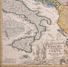
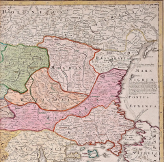
Danube River, Italy, Greece and Croatia: A Hand-colored 18th C. Homann Map
-
Description
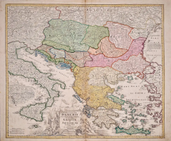
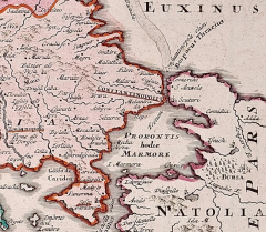
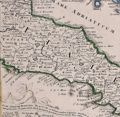
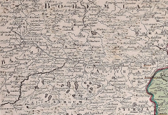
"Fluviorum in Europa principis Danubii" is a hand colored map of the region about the Danube river created by Johann Baptist Homann (1663-1724) in his 'Atlas Novus Terrarum', published in Nuremberg, Germany in 1728 shortly after his death. It depicts the course of the river Danube from Ingolstadt to the Black Sea, as well as the Adriatic and Aegean Seas. It extends from Bohemia in the north to Crete in the south, including Italy, Greece, Croatia and other portions of the Balkans. There is a striking decorative cartouche and a large inset map of the Upper Danube region and excellent detail of the Greek and Croatian islands, as well as the straits from the Aegean into the Black Sea.
There is a central vertical fold as issued, with mild separation inferiorly, which is reinforced on the verso, as is a small vertical tear in the upper margin. The map is otherwise in very good condition.
Johann Baptist Homann (1663-1724) was a mapmaker who founded a respected and prolific publishing company, which continued long after his death as Homann Heirs. Homann lived his entire life in Bavaria, particularly in Nuremberg. Initially, Johann trained to become a priest before converting to Protestantism and working as a notary. In 1702, Johann founded a publishing house that specialized in engravings. The firm flourished, becoming the leading map publisher in Germany and an important entity in the European map market. In 1715, Johann was named Imperial Geographer to the Holy Roman Empire by Charles VI and made a member of the Prussian Academy of Sciences. Most importantly for his business, his reputation and contacts gained him imperial printing privileges which protected his publications and recommended him to customers. -
More Information
Documentation: Signed Period: 18th Century Condition: Good. Creation Date: 1728 Styles / Movements: Traditional Incollect Reference #: 583220 -
Dimensions
W. 23.88 in; H. 20 in; D. 0.07 in; W. 60.66 cm; H. 50.8 cm; D. 0.18 cm;
Message from Seller:
Timeless Intaglio is an online gallery of rare and collectable antiquarian prints, maps and books. Although we specialize in all forms of vintage printed works on paper, the majority were created with the intaglio method of transferring ink from a plate, usually copper, to paper with a technique utilizing pressure generated by a press. Email us directly: rbreiman@timelessintaglio.com
More Listings from Timeless Intaglio – Rare Prints, Maps & Books View all 637 listings
-
Yellow-breasted Rail: An Original 19th C. Audubon Hand-colored Bird Lithograph

-
Wilson's Plover: An Original 19th C. Audubon Hand-colored Bird Lithograph

-
Peacock Butterfly & Moth: A 1st Ed. Hand-colored 18th C. Engraving by M. Harris

-
Butterflies & Moths: An Antique Hand-colored Engraving by Moses Harris

-
Apple: An 18th Century Hand-colored Botanical Engraving by J. Weinmann

-
Butterflies & Moths: A 1st Ed. Hand-colored 18th C. Engraving by M. Harris

-
Asparagus: An 18th Century Hand-colored Botanical Engraving by J. Weinmann

-
Cotton Plant: An 18th Century Hand-colored Botanical Engraving by J. Weinmann

-
Tortoise-shell Butterfly, Hawk Moth: Antique Hand-colored Engraving by M. Harris

-
The Natural History of Moths: An Antique Hand-colored Engraving by Moses Harris

-
American Coot: An Original 19th C. Audubon Hand-colored Bird Lithograph

-
Horned Grebe: An Original 19th C. Audubon Hand-colored Bird Lithograph

-
Admirable Butterflies, Magpie Moths: A Hand-colored Engraving by Moses Harris

-
American Avocet: An 19th Century Audubon Hand-colored Bird Lithograph

