


Offered by:
Timeless Intaglio – Rare Prints, Maps & Books
By Appt.
Alamo, CA 94507 , United States
Call Seller
925.272.8170
Showrooms
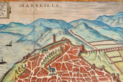
Map of Marseilles, France: A 16th Century Hand-colored Map by Braun & Hogenberg
-
Description
This is a 16th century original hand-colored copperplate engraved map of Marseilles, France entitled "Marseille" by Georg Braun & Franz Hogenberg, from their famous city atlas "Civitates Orbis Terrarum", published in Cologne, Germany in 1595.
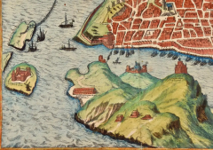
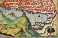
The map depicts a view of Marseilles from the southeast. There are islands to the west of the city and boats in the harbor. A mountain range lies to the north and farmland to the east. Many windmills are present in the western part of the city. Two men are depicted in the lower right looking down on Marseilles.
The small island of If is seen in the lower left. Its fortress was built by King Francis between 1524 and 1531 to defend Marseilles and France from attack. It was converted to a prison called Château d'If in the 1800's, because it was on an island surrounded by fast moving currents making escape difficult, very similar to the island prison of Alcatraz, in San Francisco. The prison played an important part in the novel 'The Count of Monte Cristo' by Alexandre Dumas. It was where the Count, Edmond Dantès, was wrongly imprisoned for 14 years and eventually made his escape.
The fortress of Notre-Dame de la Garde, built in 1525, is perched on a high limestone bluff in the foreground. This was replaced 300 years later by a neo-Byzantine church of the same name, which is the landmark of present-day Marseilles. To the left of it are the facing fortresses of Saint-Nicolas and Saint-Jean. After its founding by the Greeks around 600 BC. Marseilles became one of the most important Greek colonies due to its favourable location. In 125 BC the city asked the Roman Empire for help in defending itself against Gallic tribes, which led to its annexation by the Romans. Catacombs and writings by martryrs document the importance of Christianity in Marseilles as early as the 1st century AD; the Diocese of Marseilles also goes back to this time.
This is an English translation of an excerpt from the original text on the back of the map: "Marseilles, called Massalia in Greek, Massilia in Latin, is a rich city in Provence in France. It was built by the Greeks, which is why the inhabitants are endowed with good manners and admire and practise the liberal arts. The city allied itself with the Romans, who, however, corrupted and plundered it as a result of their pride and insatiable greed. Although Marseilles can be highly praised for a variety of reasons, Marseilles deserves eternal praise because it was one of the first cities to accept the redeeming faith directly after the birth of Christ."
References: Van der Krogt 4, 2634; Fauser, 8558; Taschen, Braun and Hogenberg, p.145, Goss, J. Braun and Hogenberg's The City Maps of Europe, pl. 72.
This striking hand-colored city view is printed on laid, chain-linked paper with wide margins. The sheet measures 15.75" high by 21.25" wide. There is a central vertical fold as issued and Latin text on the verso. There is mild discoloration and spotting in the margins. The map is otherwise in very good to excellent condition.
Braun and Hogenberg's 'The Civitates Orbis Terrarum' was the second atlas of maps ever published and the first atlas of cities and towns of the world. It is one of the most important books published in the 16th century. Most of the maps in the atlas were engraved by Franz Hogenberg and the text, with its descriptions of the history and additional factual information of the cities, was written by a team of writers and edited by Georg Braun. The work contained 546 bird-eye views and map views of cities and towns from all over the world. It gave graphic representation of the main features of the illustrated cities and towns, including the buildings and streets. Although the ordinary buildings are stylized, the principal buildings are reproduced from actual drawings created on location. The principal landmarks and streets can still be recognized today. In addition, the maps often include the heraldic arms of the city, the nature of the surrounding countryside, the important rivers, streams and harbors, even depicting stone bridges, wooden pontoons, flat-bottomed ferries, ships and working boats, wharves and jetties, as well as land-based activities, including horsemen, pedestrians, wagons, coaches, and palanquins. Small vignettes are often included which illustrate the trade, occupations and habits of the local inhabitants, such as agriculture, paper-making and textiles, as well as local forms of punishment, such as gibbets, wheels, floggings etc. Large figures dressed in their local costume are often presented out of proportion in the foreground. The aim of the authors was to give as much information as possible in a pleasing visual form. They succeeded in creating maps that were both informative and decorative works of art. The atlas is a wonderful glimpse of life in medieval Europe.
Georg Braun (1541-1622) was German Catholic cleric who was born and who died in Cologne, Germany. He was the principal editor of 'The Civitates Orbis Terrarum', acquiring the tables, hiring the artists, and composing the texts. Abraham Ortelius, whose Theatrum Orbis Terrarum of 1570 was the first atlas of maps ever published, assisted Braun in his compilation of the details and maps for the atlas. The Civitates was intended as a companion for the Ortellius' Theatrum, as suggested by the similarity in the titles. Braun was the only survivor of the original team to live to see the publication of last volume (VI) in 1617.
Franz Hogenberg (1535-1590) was a Flemish and German painter, engraver, and mapmaker. He was born in Mechelen (also known as Malines) in Flanders, the son of an engraver. After being expelled from Antwerp by the Duke of Alva, he moved to London and then eventually to Cologne, Germany, where he met Georg Braun and Abraham Ortellius. He engraved most of the plates for Ortelius's Theatrum and the majority of those in the Civitates. Many believe that he was responsible for originating the Civitates project.
Over a hundred of different artists and cartographers, the most significant of whom was Antwerp artist Georg (Joris) Hoefnagel (1542-1600), engraved the copper-plates of the Civitates from drawings. He not only contributed most of the original material for the Spanish and Italian towns but also reworked and modified those of other contributors. After Hoefnagel's death his son Jakob continued the work for the Civitates. -
More Information
Documentation: Signed Period: Pre 18th Century Condition: Good. Styles / Movements: Traditional Incollect Reference #: 602477 -
Dimensions
W. 21.25 in; H. 15.75 in; W. 53.98 cm; H. 40.01 cm;
Message from Seller:
Timeless Intaglio is an online gallery of rare and collectable antiquarian prints, maps and books. Although we specialize in all forms of vintage printed works on paper, the majority were created with the intaglio method of transferring ink from a plate, usually copper, to paper with a technique utilizing pressure generated by a press. Email us directly: rbreiman@timelessintaglio.com
More Listings from Timeless Intaglio – Rare Prints, Maps & Books View all 637 listings
-
Yellow-breasted Rail: An Original 19th C. Audubon Hand-colored Bird Lithograph

-
Butterflies & Moths: An Antique Hand-colored Engraving by Moses Harris

-
Butterflies & Moths: A 1st Ed. Hand-colored 18th C. Engraving by M. Harris

-
Apple: An 18th Century Hand-colored Botanical Engraving by J. Weinmann

-
American Coot: An Original 19th C. Audubon Hand-colored Bird Lithograph

-
Cotton Plant: An 18th Century Hand-colored Botanical Engraving by J. Weinmann

-
Tortoise-shell Butterfly, Hawk Moth: Antique Hand-colored Engraving by M. Harris

-
Horned Grebe: An Original 19th C. Audubon Hand-colored Bird Lithograph

-
Peacock Butterfly & Moth: A 1st Ed. Hand-colored 18th C. Engraving by M. Harris

-
The Natural History of Moths: An Antique Hand-colored Engraving by Moses Harris

-
Natural History of Moths and a Beetle: A Hand-colored Engraving by Moses Harris

-
Wilson's Plover: An Original 19th C. Audubon Hand-colored Bird Lithograph

-
Asparagus: An 18th Century Hand-colored Botanical Engraving by J. Weinmann

-
American Avocet: An 19th Century Audubon Hand-colored Bird Lithograph

