


Offered by:
Timeless Intaglio – Rare Prints, Maps & Books
By Appt.
Alamo, CA 94507 , United States
Call Seller
925.272.8170
Showrooms
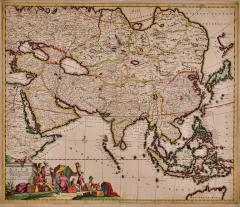
Asia Declineatio: A 17th Century Hand-colored Map of Asia by Justus Danckerts
-
Description
This is a scarce 17th century beautifully hand-colored copperplate engraved map of Asia entitled “Exactissima Asiae Delineatio in Praecipuas Regiones Caerterasque Partes divisa et denuo in lucem edita” by the Dutch cartographer Justus Danckerts. It was published in Amsterdam in 1685 in 'Atlas, Tot Amsterdam'. This very rare and attractive late 17th century map depicts Asia, India, Indonesia, the Maldives, East Indies, extending to northern Australia in the south, Japan in the west, the Mediterranean, the Red Sea, Arabia and Asia Minor in the east and Russia and China in the north. It includes a detailed view of Persia, Mongolia, Indonesia and the Philippines. The extent of European knowledge of the region is depicted reflecting the surveys of the Dutch East India Company. The work of the Jesuit missionaries is reflected in the well-documented region of China, while there is less information presented in northern and central Asia. Interesting projection of Japan and nice detail in China. The Philippines and Southeast Asian landmasses are disproportionately large, with the surrounding seas much smaller than actual size. The imaginary landmass "Yedso", also known as "Jesso", is depicted north of Japan. There is a colorful title cartouche in the lower left with a camel, apparent merchants and men working on packaged merchandise.
This rare strikingly attractive hand-colored map is printed on laid, chain-linked paper. The sheet measures 20" high and 23.38." wide. There is a central vertical fold, as issued. There is a short tear at the edge of the sheet in the lower left corner, professionally repaired on the verso and a small amount of color offset and discoloration. The map is otherwise in very good condition.
Justus Danckerts (1635-1701) was a Dutch cartographer and engraver who worked primarily in Amsterdam during the late 17th century. He was the son of the prominent mapmaker and engraver Cornelis Danckerts, and he continued his family's legacy by producing a wide range of maps, atlases, and prints. The Danckerts family of Amsterdam was one of the best known print and map sellers in 17th century Amsterdam. Their business activity covered the period from around 1633 when Cornelis Danckerts the elder (1603-1656) founded the business, to 1727 when the remaining stocks of maps in the shop of Theodorus Danckerts, his grandson, was sold. The house of Danckerts gained its greatest fame from Justus Danckerts (I. Danckerts), the maker of this map and the son of Cornelis. The majority of Danckert’s atlases were published between 1660 and 1720 and are very rare with very few complete copies surviving.
Justus Danckerts was known for his skill in engraving and printing techniques and for his high-quality, detailed and accurate maps, which were highly regarded by navigators, merchants, and scholars around the world. Danckerts produced a number of important maps and atlases during his career, including the "Atlas Novus" and the "Atlas Coelestis". He created maps of Europe, Asia, Africa, and the Americas, as well as city plans of Amsterdam, Paris, and other major European cities. Danckerts was also involved in the art trade and collected a number of valuable paintings, including works by Rembrandt and Vermeer. He was a member of the Amsterdam Guild of Saint Luke and held various civic positions in the city throughout his life. Today, Danckerts' maps and prints are highly sought after by collectors and are held in major museums and archives around the world. His contributions to cartography and printmaking continue to be appreciated and studied by scholars, collectors and enthusiasts alike. -
More Information
Documentation: Documented elsewhere (similar item) Period: Pre 18th Century Condition: Good. Styles / Movements: Traditional Incollect Reference #: 631364 -
Dimensions
W. 23.38 in; H. 20 in; W. 59.39 cm; H. 50.8 cm;
Message from Seller:
Timeless Intaglio is an online gallery of rare and collectable antiquarian prints, maps and books. Although we specialize in all forms of vintage printed works on paper, the majority were created with the intaglio method of transferring ink from a plate, usually copper, to paper with a technique utilizing pressure generated by a press. Email us directly: rbreiman@timelessintaglio.com
More Listings from Timeless Intaglio – Rare Prints, Maps & Books View all 637 listings
-
Butterflies & Moths: An Antique Hand-colored Engraving by Moses Harris

-
American Avocet: An 19th Century Audubon Hand-colored Bird Lithograph

-
Cotton Plant: An 18th Century Hand-colored Botanical Engraving by J. Weinmann

-
Natural History of Moths and a Beetle: A Hand-colored Engraving by Moses Harris

-
Admirable Butterflies, Magpie Moths: A Hand-colored Engraving by Moses Harris

-
Butterflies & Moths: A 1st Ed. Hand-colored 18th C. Engraving by M. Harris

-
Apple: An 18th Century Hand-colored Botanical Engraving by J. Weinmann

-
Wilson's Plover: An Original 19th C. Audubon Hand-colored Bird Lithograph

-
Peacock Butterfly & Moth: A 1st Ed. Hand-colored 18th C. Engraving by M. Harris

-
American Coot: An Original 19th C. Audubon Hand-colored Bird Lithograph

-
Asparagus: An 18th Century Hand-colored Botanical Engraving by J. Weinmann

-
Yellow-breasted Rail: An Original 19th C. Audubon Hand-colored Bird Lithograph

-
Tortoise-shell Butterfly, Hawk Moth: Antique Hand-colored Engraving by M. Harris

-
The Natural History of Moths: An Antique Hand-colored Engraving by Moses Harris

