


Offered by:
Timeless Intaglio – Rare Prints, Maps & Books
By Appt.
Alamo, CA 94507 , United States
Call Seller
925.272.8170
Showrooms
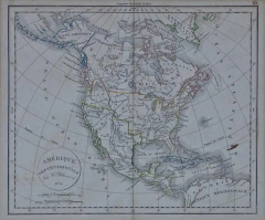
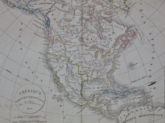
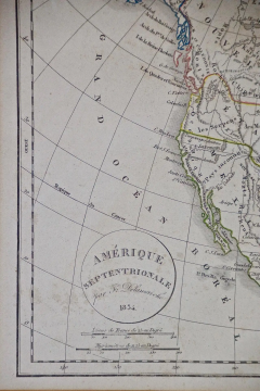
America "Amérique Septentrionale": A 19th Century French Map by Delamarche
-
Description
This framed mid 19th century map of North America entitled "Amérique Septentrionale" by Felix Delamarche was published in Paris in 1854 by Quay de l'Horloge du Palais, avec les Cartes de Guill. Delisle et de Phil. Buache.
The map includes Central America (labelled Guatimala), portions of Columbia in South America and portions of Greenland, as well as Cuba, Haiti and Santa Dominique (The Dominican Republic). Modern day Alaska is labelled Russie Americaine. Many of the areas in the midwest and west of the United States are named for the Native American tribes that live in the region, rather than their eventual English names. These territories in modern day Colorado, Arizona, New Mexico, Texas, Washington and Oregon include: Les Osage, Les Sioux, Les Mandanes, Les Chactas, Chipeouays, Les Serpens. California and the southwestern states are still part of Mexico at the time this map was published.
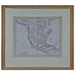
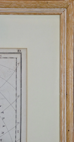
The map, which is colored in outline, is presented in a light brown distressed bleached wood frame with a cream-colored mat. The frame measures 22.63" wide x 20" high x 0.88" deep. There are two other 19th century maps of North America (the United States and one including Mexico) listed on 1stdibs that are presented in identical style frames and mats. They can be seen by entering their reference #'s (LULU5206221574182 or LULU5206221506302) in the search field. These would make an interesting and attractive grouping. A discount is available for purchase of a grouping of two or three of these maps.
There is a central vertical fold, as issued. The map is somewhat toned, although the appearance appears in part to be related to its tinting. There is some faint spotting, most prominently in the left lower portions of the map. It is otherwise in very good condition.
Félix Delamarche was a French geographer and engineer who flourished during the 18th century and early 19th century.[1][2] His father was the map publisher Charles Francois Delamarche.
Félix Delamarche became the owner of his father's map publishing company, Maison Delamarche. He ran the company alongside cartographer Charles Dien. The firm would eventually be passed down to Alexandre Delamarche.[1] Delamarche created Atlas de la géographie ancienne et moderne in 1820. The atlas was reprinted during the 19th century. It was utilized by the Ecole Spéciale Militaire de Saint-Cyr. His work is held in the collection of the Library of Congress.[3] -
More Information
Period: 19th Century Condition: Good. Styles / Movements: Americana, Traditional Incollect Reference #: 585028 -
Dimensions
W. 22.63 in; H. 20 in; D. 0.88 in; W. 57.48 cm; H. 50.8 cm; D. 2.24 cm;
Message from Seller:
Timeless Intaglio is an online gallery of rare and collectable antiquarian prints, maps and books. Although we specialize in all forms of vintage printed works on paper, the majority were created with the intaglio method of transferring ink from a plate, usually copper, to paper with a technique utilizing pressure generated by a press. Email us directly: rbreiman@timelessintaglio.com
More Listings from Timeless Intaglio – Rare Prints, Maps & Books View all 637 listings
-
Admirable Butterflies, Magpie Moths: A Hand-colored Engraving by Moses Harris

-
Natural History of Moths and a Beetle: A Hand-colored Engraving by Moses Harris

-
Wilson's Plover: An Original 19th C. Audubon Hand-colored Bird Lithograph

-
Butterflies & Moths: An Antique Hand-colored Engraving by Moses Harris

-
Cotton Plant: An 18th Century Hand-colored Botanical Engraving by J. Weinmann

-
American Coot: An Original 19th C. Audubon Hand-colored Bird Lithograph

-
The Natural History of Moths: An Antique Hand-colored Engraving by Moses Harris

-
Butterflies & Moths: A 1st Ed. Hand-colored 18th C. Engraving by M. Harris

-
American Avocet: An 19th Century Audubon Hand-colored Bird Lithograph

-
Apple: An 18th Century Hand-colored Botanical Engraving by J. Weinmann

-
Peacock Butterfly & Moth: A 1st Ed. Hand-colored 18th C. Engraving by M. Harris

-
Asparagus: An 18th Century Hand-colored Botanical Engraving by J. Weinmann

-
Horned Grebe: An Original 19th C. Audubon Hand-colored Bird Lithograph

-
Tortoise-shell Butterfly, Hawk Moth: Antique Hand-colored Engraving by M. Harris

