Offered by:
Timeless Intaglio – Rare Prints, Maps & Books
By Appt.
Alamo, CA 94507 , United States
Call Seller
925.272.8170
Showrooms
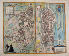
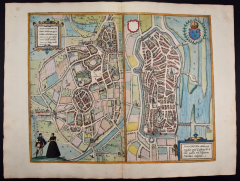
Nevers & Autun France: 16th Century Hand-colored Map by Braun & Hogenberg
-
Description
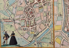
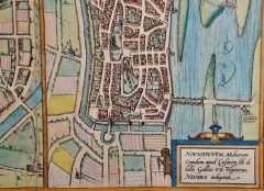
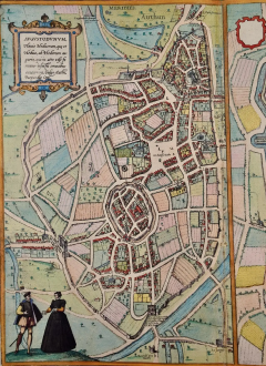
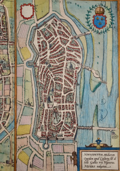
This is a pair of 16th century original hand-colored copperplate engraved maps on one sheet by Georg Braun & Franz Hogenberg, in volume III of their famous city atlas "Civitates Orbis Terrarum", published in Cologne, Germany in 1575. The map on the left, a bird's-eye View of Autun, France, is entitled "Augustodunum, Flavia Heduorum, que et Hedua, ab Hedorum augurio ...." and the map on the right, a bird's-eye view of Nevers, France is entitled: Noviodunum, Aeduorum Oppidum apud Casearem lib. de bello Gallico VII Vigenerus, Nevers indigetat.
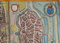
The colorful map of Autun on the left includes a title cartouche in the upper left with Latin text. A man and a woman are standing on a hill in the foreground dressed in the style of 16th century upper class residents of the town. A title cartouche containing Latin is [resent in the lower right corner of the map of Nevers, along with a crest in the right upper corner.
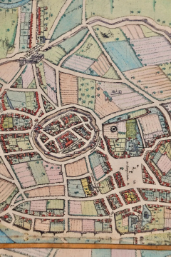
The bird's-eye view of Autun from the west depicts a spacious tract of land bordered by city walls on the far side of the small Arroux River, shown in the foreground. The oval district of Marchaux is in the center of town, with two Roman gateways. Autun was founded by Emperor Augustus following the suppression of the Gauls in 10 BC and called Augustodunum after him. The Roman Temple of Janus is in the lower right. The cathedral of Saint-Lazare is in the upper right. During the Middle Ages the relics of St Lazarus attracted flocks of lepers, who made the pelgrimage to Autun in the hope of a rapid cure.
This is an English translation of an excerpt of Braun's description of Autun: ""Autun lies at the foot of several mountains, it is a town in Burgundy with only a few buildings, except for the spot where the castle and the church of Saint-Lazare stand. This Lazarus was the brother of Mary Magdalene, who, after being resurrected from the dead by Christ, came to France to spread the Gospel after Christ's Ascension. His body was buried in this church and reverently preserved as a relic. The other, separate part of the town, now called Marchaux in French, was formerly the champ de mars."
The translation of the title cartouche for Nevers reads: Noviodunum, according to Vigenerus in the seventh book of Caesar's Bellum Gallico the city of the Aedui, locally called Nevers. The bird's-eye view shows the city situated in Burgundy on the Loire River. The elongated Old Town features a complex maze of narrow alleys. The city was settled in Gallo-Roman times. The Palais Ducale is in the center of the city. It is one of the most important feudal buildings in central France. The cathedral of Saint-Cyr-et-Sainte-Juliette lies beneath the Palais Ducale. Nevers has been regarded as the ceramics capital of France since the 17th century.
This is an English translation of an excerpt of Braun's description of Nevers: "Noviodum, an important city in the Duchy of Nevers, lies on the Loire and takes its name from its location, since donum once meant mountain or hill in Old French. For it lies on a hill where the Nièvre flows into the Loire. All the buildings are well protected by a secure ring wall, commanding towers and a very deep moat."
References: Van der Krogt 4, 319; Taschen, Braun and Hogenberg, p.215.
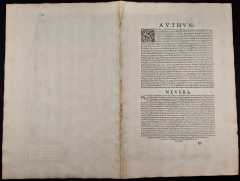
This striking beautifully hand-colored city view is printed on laid, chain-linked paper with wide margins. The sheet measures 16" high by 21" wide. There is Latin on the front and French text on the verso. There is a central vertical fold as issued, which is reinforced. There is mild discoloration and a few spots in the margins. The map is otherwise in very good condition.
Braun and Hogenberg's 'The Civitates Orbis Terrarum' was the second atlas of maps ever published and the first atlas of cities and towns of the world. It is one of the most important books published in the 16th century. Most of the maps in the atlas were engraved by Franz Hogenberg and the text, with its descriptions of the history and additional factual information of the cities, was written by a team of writers and edited by Georg Braun. The work contained 546 bird-eye views and map views of cities and towns from all over the world. It gave graphic representation of the main features of the illustrated cities and towns, including the buildings and streets. Although the ordinary buildings are stylized, the principal buildings are reproduced from actual drawings created on location. The principal landmarks and streets can still be recognized today. In addition, the maps often include the heraldic arms of the city, the nature of the surrounding countryside, the important rivers, streams and harbors, even depicting stone bridges, wooden pontoons, flat-bottomed ferries, ships and working boats, wharves and jetties, as well as land-based activities, including horsemen, pedestrians, wagons, coaches, and palanquins. Small vignettes are often included which illustrate the trade, occupations and habits of the local inhabitants, such as agriculture, paper-making and textiles, as well as local forms of punishment, such as gibbets, wheels, floggings etc. Large figures dressed in their local costume are often presented out of proportion in the foreground. The aim of the authors was to give as much information as possible in a pleasing visual form. They succeeded in creating maps that were both informative and decorative works of art. The atlas is a wonderful glimpse of life in medieval Europe.
Georg Braun (1541-1622) was German Catholic cleric who was born and who died in Cologne, Germany. He was the principal editor of 'The Civitates Orbis Terrarum', acquiring the tables, hiring the artists, and composing the texts. Abraham Ortelius, whose Theatrum Orbis Terrarum of 1570 was the first atlas of maps ever published, assisted Braun in his compilation of the details and maps for the atlas. The Civitates was intended as a companion for the Ortellius' Theatrum, as suggested by the similarity in the titles. Braun was the only survivor of the original team to live to see the publication of last volume (VI) in 1617.
Franz Hogenberg (1535-1590) was a Flemish and German painter, engraver, and mapmaker. He was born in Mechelen (also known as Malines) in Flanders, the son of an engraver. After being expelled from Antwerp by the Duke of Alva, he moved to London and then eventually to Cologne, Germany, where he met Georg Braun and Abraham Ortellius. He engraved most of the plates for Ortelius's Theatrum and the majority of those in the Civitates. Many believe that he was responsible for originating the Civitates project.
Over a hundred of different artists and cartographers, the most significant of whom was Antwerp artist Georg (Joris) Hoefnagel (1542-1600), engraved the copper-plates of the Civitates from drawings. He not only contributed most of the original material for the Spanish and Italian towns but also reworked and modified those of other contributors. After Hoefnagel's death his son Jakob continued the work for the Civitates. -
More Information
Documentation: Signed Period: Pre 18th Century Condition: Good. Creation Date: 1575 Styles / Movements: Traditional Incollect Reference #: 608701 -
Dimensions
W. 21 in; H. 16 in; W. 53.34 cm; H. 40.64 cm;
Message from Seller:
Timeless Intaglio is an online gallery of rare and collectable antiquarian prints, maps and books. Although we specialize in all forms of vintage printed works on paper, the majority were created with the intaglio method of transferring ink from a plate, usually copper, to paper with a technique utilizing pressure generated by a press. Email us directly: rbreiman@timelessintaglio.com
More Listings from Timeless Intaglio – Rare Prints, Maps & Books View all 640 listings
-
Burning Bush: An 18th Century Hand-colored Botanical Engraving by J. Weinmann
-
Tortoise-shell Butterfly, Hawk Moth: Antique Hand-colored Engraving by M. Harris

-
Butterflies & Moths: An Antique Hand-colored Engraving by Moses Harris

-
Cotton Plant: An 18th Century Hand-colored Botanical Engraving by J. Weinmann

-
American Coot: An Original 19th C. Audubon Hand-colored Bird Lithograph

-
Apple: An 18th Century Hand-colored Botanical Engraving by J. Weinmann

-
Butterflies & Moths: A 1st Ed. Hand-colored 18th C. Engraving by M. Harris

-
Natural History of Moths and a Beetle: A Hand-colored Engraving by Moses Harris

-
Red Geranium: An 18th Century Hand-colored Botanical Engraving by J. Weinmann
-
The Natural History of Moths: An Antique Hand-colored Engraving by Moses Harris

-
Peacock Butterfly & Moth: A 1st Ed. Hand-colored 18th C. Engraving by M. Harris

-
American Avocet: An 19th Century Audubon Hand-colored Bird Lithograph

-
Admirable Butterflies, Magpie Moths: A Hand-colored Engraving by Moses Harris

-
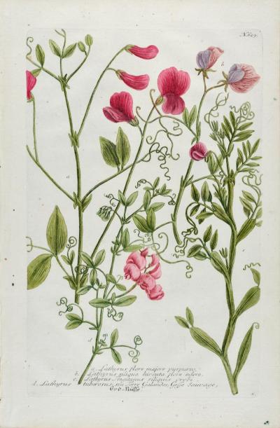
Red Sweet Pea: An 18th Century Hand-colored Botanical Engraving by J. Weinmann