


Offered by:
Timeless Intaglio – Rare Prints, Maps & Books
By Appt.
Alamo, CA 94507 , United States
Call Seller
925.272.8170
Showrooms
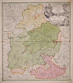
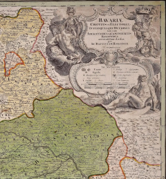
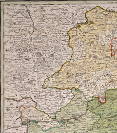
Hand Colored 18th C. Homann Map of Bavaria & Portions of Austria and Switzerland
-
Description
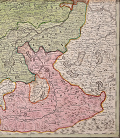
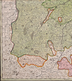
This hand colored map of Bavaria in Southern Germany and portions of Austria and Switzerland entitled "Bavariae Circulus et Electorat, in suas quasaque Ditiones tam cum Adjacentibus quam Insertis Regionibus accuratisime divisus per Io: Baptistam Homannum Norimbergae" was created by Johann Baptist Homann and published in Nuremberg, Germany in 1728 shortly after his death. It includes Munich, Salzburg, Passau, Bamberg, Nuremberg, Augsburg and Innsbruck. The map detail cities, forts, mountains, forests and lakes, as well as districts. The beautiful elaborate cartouche in the upper right depicts people, cherubs, lions, weapons, an armorial royal crest and decorative scroll work
There is mild discoloration along the horizantal fold and some mild focal discoloration in the margins. The map is otherwise in very good condition.
Johann Baptist Homann (1663-1724) was a mapmaker who founded a respected and prolific publishing company, which continued long after his death as Homann Heirs. Homann lived his entire life in Bavaria, particularly in Nuremberg. Initially, Johann trained to become a priest before converting to Protestantism and working as a notary. In 1702, Johann founded a publishing house that specialized in engravings. The firm flourished, becoming the leading map publisher in Germany and an important entity in the European map market. In 1715, Johann was named Imperial Geographer to the Holy Roman Empire by Charles VI and made a member of the Prussian Academy of Sciences. Most importantly for his business, his reputation and contacts gained him imperial printing privileges which protected his publications and recommended him to customers. -
More Information
Documentation: Signed Period: Pre 18th Century Creation Date: 1728 Styles / Movements: Traditional Incollect Reference #: 574756 -
Dimensions
W. 20.25 in; H. 23.63 in; W. 51.44 cm; H. 60.02 cm;
Message from Seller:
Timeless Intaglio is an online gallery of rare and collectable antiquarian prints, maps and books. Although we specialize in all forms of vintage printed works on paper, the majority were created with the intaglio method of transferring ink from a plate, usually copper, to paper with a technique utilizing pressure generated by a press. Email us directly: rbreiman@timelessintaglio.com
More Listings from Timeless Intaglio – Rare Prints, Maps & Books View all 637 listings
-
Admirable Butterflies, Magpie Moths: A Hand-colored Engraving by Moses Harris

-
Horned Grebe: An Original 19th C. Audubon Hand-colored Bird Lithograph

-
Peacock Butterfly & Moth: A 1st Ed. Hand-colored 18th C. Engraving by M. Harris

-
Butterflies & Moths: A 1st Ed. Hand-colored 18th C. Engraving by M. Harris

-
Yellow-breasted Rail: An Original 19th C. Audubon Hand-colored Bird Lithograph

-
The Natural History of Moths: An Antique Hand-colored Engraving by Moses Harris

-
American Coot: An Original 19th C. Audubon Hand-colored Bird Lithograph

-
Wilson's Plover: An Original 19th C. Audubon Hand-colored Bird Lithograph

-
American Avocet: An 19th Century Audubon Hand-colored Bird Lithograph

-
Tortoise-shell Butterfly, Hawk Moth: Antique Hand-colored Engraving by M. Harris

-
Natural History of Moths and a Beetle: A Hand-colored Engraving by Moses Harris

-
Butterflies & Moths: An Antique Hand-colored Engraving by Moses Harris

-
Asparagus: An 18th Century Hand-colored Botanical Engraving by J. Weinmann

-
Cotton Plant: An 18th Century Hand-colored Botanical Engraving by J. Weinmann

