


Offered by:
Timeless Intaglio – Rare Prints, Maps & Books
By Appt.
Alamo, CA 94507 , United States
Call Seller
925.272.8170
Showrooms
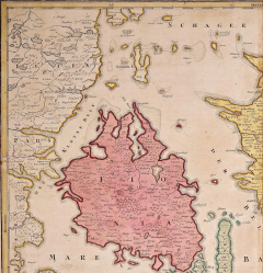
Hand-Colored 18th Century Homann Map of Denmark and Islands in the Baltic Sea
-
Description
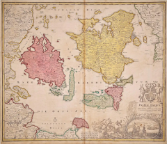
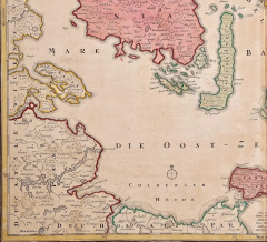
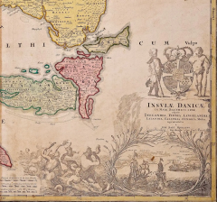
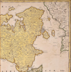
An 18th century copper plate hand-colored map entitled "Insulae Danicae in Mari Balthico Sitae utpote Zeelandia, Fionia, Langelandia, Lalandia, Falstria, Fembria Mona" created by Johann Baptist Homann (1663-1724) in his 'Atlas Novus Terrarum', published in Nuremberg, Germany in 1720. It depicts the country of Denmark, including Copenhagen, Malmö, Cronenburg and its islands located in the Baltic Sea, including Zeeland, Fionia, Langeland, Laland, Falstria and Fembria Mona. The beautiful and detailed cartouche in the lower right corner depicts ships in the strait between Sweden and Denmark, as well as two children holding up a royal coat-of-arms at the top and mermaids or gods of the sea in the water on the left.
There is a central vertical fold as issued with associated mild toning adjacent toning. Minimal toning in the lower margin, but the map is otherwise in very good condition.
Johann Baptist Homann (1663-1724) was a mapmaker who founded a respected and prolific publishing company, which continued long after his death as Homann Heirs. Homann lived his entire life in Bavaria, particularly in Nuremberg. Initially, Johann trained to become a priest before converting to Protestantism and working as a notary. In 1702, Johann founded a publishing house that specialized in engravings. The firm flourished, becoming the leading map publisher in Germany and an important entity in the European map market. In 1715, Johann was named Imperial Geographer to the Holy Roman Empire by Charles VI and made a member of the Prussian Academy of Sciences. Most importantly for his business, his reputation and contacts gained him imperial printing privileges which protected his publications and recommended him to customers. -
More Information
Documentation: Documented elsewhere (similar item) Period: 18th Century Condition: Good. Styles / Movements: Traditional Incollect Reference #: 587310 -
Dimensions
W. 23.25 in; H. 20.25 in; D. 0.07 in; W. 59.06 cm; H. 51.44 cm; D. 0.18 cm;
Message from Seller:
Timeless Intaglio is an online gallery of rare and collectable antiquarian prints, maps and books. Although we specialize in all forms of vintage printed works on paper, the majority were created with the intaglio method of transferring ink from a plate, usually copper, to paper with a technique utilizing pressure generated by a press. Email us directly: rbreiman@timelessintaglio.com
More Listings from Timeless Intaglio – Rare Prints, Maps & Books View all 637 listings
-
Apple: An 18th Century Hand-colored Botanical Engraving by J. Weinmann

-
Asparagus: An 18th Century Hand-colored Botanical Engraving by J. Weinmann

-
American Coot: An Original 19th C. Audubon Hand-colored Bird Lithograph

-
Admirable Butterflies, Magpie Moths: A Hand-colored Engraving by Moses Harris

-
Natural History of Moths and a Beetle: A Hand-colored Engraving by Moses Harris

-
Butterflies & Moths: An Antique Hand-colored Engraving by Moses Harris

-
Cotton Plant: An 18th Century Hand-colored Botanical Engraving by J. Weinmann

-
Yellow-breasted Rail: An Original 19th C. Audubon Hand-colored Bird Lithograph

-
The Natural History of Moths: An Antique Hand-colored Engraving by Moses Harris

-
Butterflies & Moths: A 1st Ed. Hand-colored 18th C. Engraving by M. Harris

-
Horned Grebe: An Original 19th C. Audubon Hand-colored Bird Lithograph

-
Peacock Butterfly & Moth: A 1st Ed. Hand-colored 18th C. Engraving by M. Harris

-
American Avocet: An 19th Century Audubon Hand-colored Bird Lithograph

-
Wilson's Plover: An Original 19th C. Audubon Hand-colored Bird Lithograph

