


Offered by:
Timeless Intaglio – Rare Prints, Maps & Books
By Appt.
Alamo, CA 94507 , United States
Call Seller
925.272.8170
Showrooms
Cadiz Island: A Framed 17th Century Hand-colored Map from Blaeu's Atlas Major
-
Description
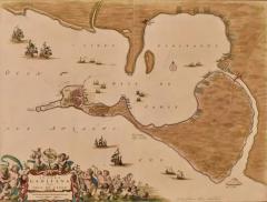
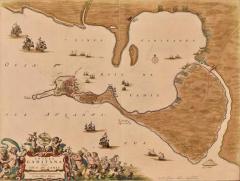
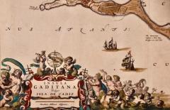
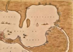
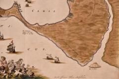
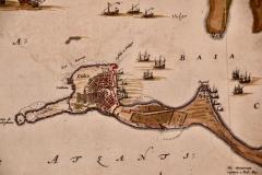
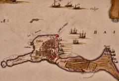
This is a 17th century hand-colored map entitled "Insula Gaditana Isla de Cadiz" from Johannes (Joan) Blaeu's Atlas Maior, published in Amsterdam in 1662.
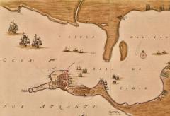
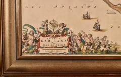
The map provides an excellent plan of Cadiz Island on the southwest coast of Spain, with its harbor, fortifications, agricultural fields and several surrounding salt processing areas. Numerous sailing ships of various sizes are included in and around the harbor and bay, including five large sailing ships, as well as twenty-four smaller ships. There is a small compass rose overlying the bay. The bridge to the mainland from the island is shown on the right. There is an extremely ornate and colorful title cartouche in the lower left, with its mythological figures reminiscent of Raphael’s Galatea fresco at the Villa Farnesina in Rome. The vibrant colors are vividly preserved. The master colorist tried to emulate a painting by using various tones to create a three-dimensional effect. Blaeu's name is present in the plate in the lower right. Blaeu stated in his description of Cadiz: “The main wealth of the islanders consists of salt, which they harvest, and the tuna fisheries.”
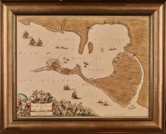
This 17th century hand-colored map is framed in an ornate, partially textured bronze-colored wood frame and glazed with UV protected conservation glass. There is a vertical center fold, as issued. There is a faint crease in the lower right and faint color offset on the left from the right side of the map, resulting from having been in an atlas for hundreds of years. Small foci of paint are present in the upper portion of the left margin and in the left corner margin. The map is otherwise in very good condition.
Due in large part to their powerful trade empire, the Dutch became known for cartography in the seventeenth century. This period is considered the Golden Age of Dutch cartography. Their publishing houses produced the highest quality work in Europe, particularly those maps and charts of foreign lands, and Dutch map-making set the bar for cartographic accuracy and artistry into the early-eighteenth century. Some of the most well-known cartographers worked in Amsterdam during this period. Perhaps the most famous of these was the Blaeu family. Willem Janszoon Blaeu, set up shop in Amsterdam. His son, Johannes (Joan), succeeded him upon his death in 1638, continuing in his father’s position as Hydrographer to the Dutch East India Company and selling maps to the public. The Blaeu map presses, located near Amsterdam’s Dam Square, were the largest the world had ever seen up to that time. When the printing press warehouse burned in 1672, it signalled the end of the Dutch Golden Age of cartography.
Johannes (Joan) Blaeu (1596-1673) was a Dutch cartographer, astronomer, and publisher who played a significant role in the development of map-making during the 17th century. Born in Alkmaar, Netherlands, Blaeu studied law before becoming interested in astronomy and cartography. He began his career as an apprentice to his father, Willem Blaeu, who was also a renowned cartographer. After his father's death in 1638, Johannes Blaeu took over the family business and expanded it by producing some of the most beautiful and accurate maps of his time. He published a number of atlases, including the famous "Atlas Maior," which contained hundreds of maps, including this one, and was considered the most expensive book of its time. Blaeu's maps were highly sought after and were used by explorers, traders, and governments around the world. He was also appointed the official cartographer to the Dutch East India Company and created maps of their trading routes and colonies.
In addition to his cartographic work, Blaeu was also an accomplished astronomer and made important contributions to the field. He was a member of the Royal Society in London and corresponded with some of the leading scientists of his time. Johannes Blaeu's legacy lives on through his maps, which are still highly prized by collectors and historians today. His work helped to advance the field of cartography and made significant contributions to our understanding of the world during the 17th century. -
More Information
Documentation: Documented elsewhere (similar item) Period: Pre 18th Century Condition: Good. Styles / Movements: Traditional Incollect Reference #: 634596 -
Dimensions
W. 24.88 in; H. 20 in; D. 1.13 in; W. 63.2 cm; H. 50.8 cm; D. 2.87 cm;
Message from Seller:
Timeless Intaglio is an online gallery of rare and collectable antiquarian prints, maps and books. Although we specialize in all forms of vintage printed works on paper, the majority were created with the intaglio method of transferring ink from a plate, usually copper, to paper with a technique utilizing pressure generated by a press. Email us directly: rbreiman@timelessintaglio.com
More Listings from Timeless Intaglio – Rare Prints, Maps & Books View all 640 listings
-
American Avocet: An 19th Century Audubon Hand-colored Bird Lithograph

-
Apple: An 18th Century Hand-colored Botanical Engraving by J. Weinmann

-
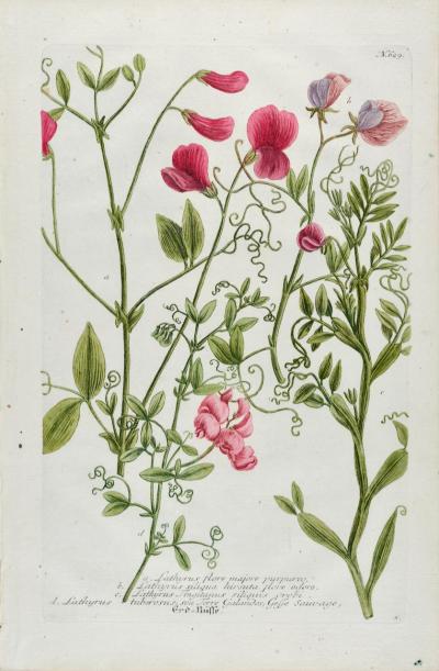
Red Sweet Pea: An 18th Century Hand-colored Botanical Engraving by J. Weinmann
-
The Natural History of Moths: An Antique Hand-colored Engraving by Moses Harris

-
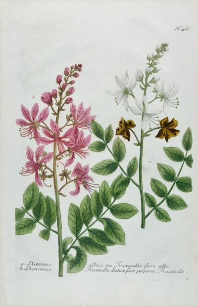
Burning Bush: An 18th Century Hand-colored Botanical Engraving by J. Weinmann
-
American Coot: An Original 19th C. Audubon Hand-colored Bird Lithograph

-
Natural History of Moths and a Beetle: A Hand-colored Engraving by Moses Harris

-
Butterflies & Moths: A 1st Ed. Hand-colored 18th C. Engraving by M. Harris

-
Cotton Plant: An 18th Century Hand-colored Botanical Engraving by J. Weinmann

-
Peacock Butterfly & Moth: A 1st Ed. Hand-colored 18th C. Engraving by M. Harris

-
Butterflies & Moths: An Antique Hand-colored Engraving by Moses Harris

-
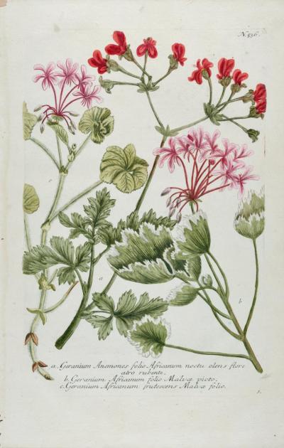
Red Geranium: An 18th Century Hand-colored Botanical Engraving by J. Weinmann
-
Admirable Butterflies, Magpie Moths: A Hand-colored Engraving by Moses Harris

-
Tortoise-shell Butterfly, Hawk Moth: Antique Hand-colored Engraving by M. Harris

