
Offered by:
Timeless Intaglio – Rare Prints, Maps & Books
By Appt.
Alamo, CA 94507 , United States
Call Seller
925.272.8170
Showrooms
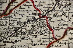
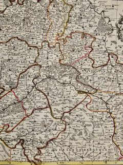
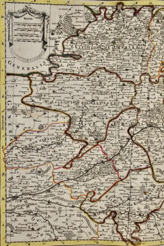
The Loire Valley of France: A 17th C. Hand-colored Map by Sanson and Jaillot
-
Description
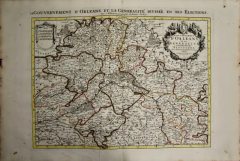
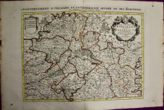
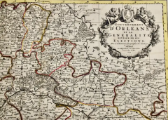
This large 17th century copper plate hand-colored engraved map entitled "Gouvernement D'Orleans et la Generalite divisee en ses Elections Par le Sanson" was originally created by Nicholas Sanson d'Abbeville and published by Hubert Jaillot in "Atlas Nouveau" in Paris in 1693. It depicts the Loire Valley region of France. Chambort, Fontainbleau, the Loire River and many other landmarks are included. There is an ornate title cartouche in the right upper corner. A young male in the upper left lies on his back, drinking from a jug, presumably wine. A young male at the top on the right is sleeping in front of another liquid vessel, possibly after drinking too much wine. A royal coat-of-arms sits between the two figures. Bunches of grapes are aligned about the periphery of the cartouche. The Loire Valley was already known for its wine in the 17th century. A draped scale cartouche is in the left upper corner.
The map consists of two sheets joined as one along a vertical joint. The map has original hand-coloring. It is printed on antique hand-made laid, chain-linked paper with wide margins. The sheet measures 24.88" high and 38" wide. There is a central vertical joint, as issued. There are several spots and some discoloration at the periphery of the margins. There is some irregularity of the left and right edges of the sheet. There is a repaired tear in the lower margin to the right of the central vertical joint. The map itself is in very good condition.
Nicholas Sanson d'Abbeville (1600-1667) was one of the greatest French cartographather of French cartography. Sanson opened his first printing business in Paris in 1638. The king recognized his skill and knowledge and made him the official geographer to the court. He eventually served two kings in this capacity. Sanson was succeeded by his sons and son-in-law in the business and as geographers to the king. In 1692 his plates were purchased by the prominent Parisian cartographer Alexis Hubert Jaillot, who continued to publish his maps and atlases with a dual Sanson and Jaillot attribution. Jaillot went on to serve King Louis XIV. -
More Information
Documentation: Signed Period: Pre 18th Century Condition: Good. Creation Date: 1692 Styles / Movements: Traditional Incollect Reference #: 580986 -
Dimensions
W. 38 in; H. 24.88 in; W. 96.52 cm; H. 63.2 cm;
Message from Seller:
Timeless Intaglio is an online gallery of rare and collectable antiquarian prints, maps and books. Although we specialize in all forms of vintage printed works on paper, the majority were created with the intaglio method of transferring ink from a plate, usually copper, to paper with a technique utilizing pressure generated by a press. Email us directly: rbreiman@timelessintaglio.com
More Listings from Timeless Intaglio – Rare Prints, Maps & Books View all 640 listings
-
Admirable Butterflies, Magpie Moths: A Hand-colored Engraving by Moses Harris

-
The Natural History of Moths: An Antique Hand-colored Engraving by Moses Harris

-
Red Sweet Pea: An 18th Century Hand-colored Botanical Engraving by J. Weinmann
-
Butterflies & Moths: An Antique Hand-colored Engraving by Moses Harris

-
Asparagus: An 18th Century Hand-colored Botanical Engraving by J. Weinmann

-
Cotton Plant: An 18th Century Hand-colored Botanical Engraving by J. Weinmann

-
Tortoise-shell Butterfly, Hawk Moth: Antique Hand-colored Engraving by M. Harris

-
Natural History of Moths and a Beetle: A Hand-colored Engraving by Moses Harris

-
Peacock Butterfly & Moth: A 1st Ed. Hand-colored 18th C. Engraving by M. Harris

-
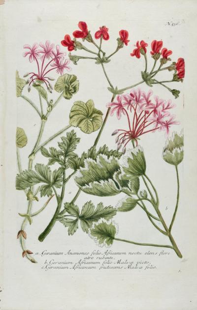
Red Geranium: An 18th Century Hand-colored Botanical Engraving by J. Weinmann
-
Apple: An 18th Century Hand-colored Botanical Engraving by J. Weinmann

-
Butterflies & Moths: A 1st Ed. Hand-colored 18th C. Engraving by M. Harris

-
American Avocet: An 19th Century Audubon Hand-colored Bird Lithograph

-
Burning Bush: An 18th Century Hand-colored Botanical Engraving by J. Weinmann