


Offered by:
Timeless Intaglio – Rare Prints, Maps & Books
By Appt.
Alamo, CA 94507 , United States
Call Seller
925.272.8170
Showrooms
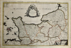
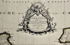
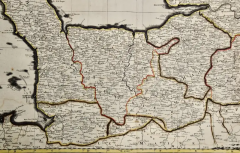
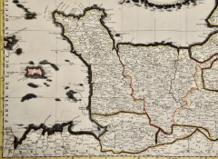
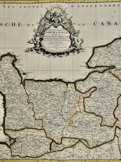
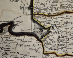
The Normandy Region of France: A 17th C. Hand-colored Map by Sanson and Jaillot
-
Description
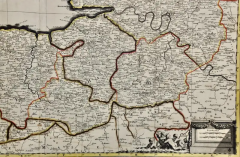
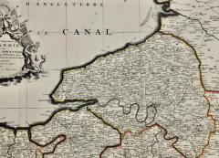
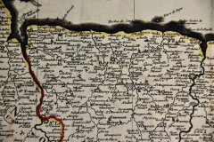
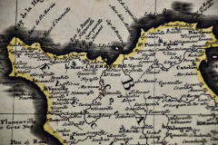
This large hand-colored map entitled "Le Duché et Gouvernement de Normandie divisée en Haute et Basse Normandie en divers Pays; et par evêchez, avec le Gouvernement General du Havre de Grace" was originally created by Nicholas Sanson d'Abbeville and published by Hubert Jaillot in "Atlas Nouveau" in Paris in 1695. It depicts the Normandy region of France. It includes Bayeaux, Mont St. Michel, Le Havre, Cherbourg and many other landmarks.
The map consists of two sheets joined as one along a vertical joint. The map has original hand-coloring and it is printed on antique hand-made laid, chain-linked paper with wide margins. The sheet measures 24.88" high and 38" wide. There is a professionally repaired tear on the verso in the lower margin to the right of the central vertical joint and reinforcement on the verso along oxidized colored border lines in the lower left. There are a few small spots and some discoloration at the periphery of the margins, with mild irregularity of the edges of the left and right margins. There is mild offset resulting from contact with the color on the opposite sides of the map over hundreds of years in the atlas. The map is otherwise in very good condition.
Nicholas Sanson d'Abbeville (1600-1667) was one of the greatest French cartographather of French cartography. Sanson opened his first printing business in Paris in 1638. The king recognized his skill and knowledge and made him the official geographer to the court. He eventually served two kings in this capacity. Sanson was succeeded by his sons and son-in-law in the business and as geographers to the king. In 1692 his plates were purchased by the prominent Parisian cartographer Alexis Hubert Jaillot (1632-1712), who continued to publish his maps and atlases with a dual Sanson and Jaillot attribution. Jaillot went on to serve King Louis XIV. -
More Information
Documentation: Signed Period: Pre 18th Century Condition: Good. Creation Date: 1695 Styles / Movements: Traditional Incollect Reference #: 580981 -
Dimensions
W. 38 in; H. 24.88 in; W. 96.52 cm; H. 63.2 cm;
Message from Seller:
Timeless Intaglio is an online gallery of rare and collectable antiquarian prints, maps and books. Although we specialize in all forms of vintage printed works on paper, the majority were created with the intaglio method of transferring ink from a plate, usually copper, to paper with a technique utilizing pressure generated by a press. Email us directly: rbreiman@timelessintaglio.com
More Listings from Timeless Intaglio – Rare Prints, Maps & Books View all 640 listings
-
American Coot: An Original 19th C. Audubon Hand-colored Bird Lithograph

-
Peacock Butterfly & Moth: A 1st Ed. Hand-colored 18th C. Engraving by M. Harris

-
Red Geranium: An 18th Century Hand-colored Botanical Engraving by J. Weinmann
-
Admirable Butterflies, Magpie Moths: A Hand-colored Engraving by Moses Harris

-
Apple: An 18th Century Hand-colored Botanical Engraving by J. Weinmann

-
Asparagus: An 18th Century Hand-colored Botanical Engraving by J. Weinmann

-
The Natural History of Moths: An Antique Hand-colored Engraving by Moses Harris

-
Natural History of Moths and a Beetle: A Hand-colored Engraving by Moses Harris

-
Butterflies & Moths: An Antique Hand-colored Engraving by Moses Harris

-
Burning Bush: An 18th Century Hand-colored Botanical Engraving by J. Weinmann
-
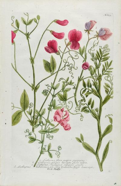
Red Sweet Pea: An 18th Century Hand-colored Botanical Engraving by J. Weinmann
-
American Avocet: An 19th Century Audubon Hand-colored Bird Lithograph

-
Tortoise-shell Butterfly, Hawk Moth: Antique Hand-colored Engraving by M. Harris

-
Butterflies & Moths: A 1st Ed. Hand-colored 18th C. Engraving by M. Harris

