


Offered by:
Timeless Intaglio – Rare Prints, Maps & Books
By Appt.
Alamo, CA 94507 , United States
Call Seller
925.272.8170
Showrooms
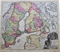
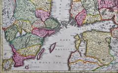
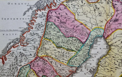
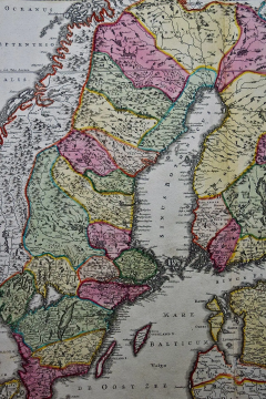
Sweden & Adjacent Portions of Scandinavia: A Hand-Colored 18th C. Map by Homann
-
Description
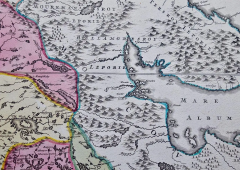
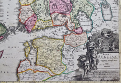
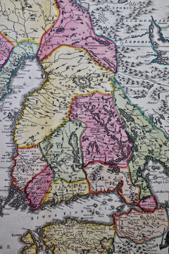
This hand-colored map of Sweden and adjacent portions of Scandinavia entitled "Regni Sueciae in Omnes suas Subjacentes Provincias accurate divisi Tabula Generalis" was created by Johann Baptist Homann in 1710 and published in Nuremberg, Germany in 1730 shortly after his death. The map detail cities, forts, mountains, forests and lakes, as well as districts. It includes Stockholm, Coppenhavi (Copenhagen), Helsingingfors, Helsingo (Helsinki), Livonia (now Estonia), Lithuania, Latvia and the Baltic Sea. The beautiful elaborate cartouche in the lower right depicts people, cherubs, a lion, weapons, an armorial royal crest and decorative scroll work
The map is beautiful han-colored. There is a central vertical fold, as issued. There is mild discoloration in the margins, but the map is otherwise in very good condition.
Johann Baptist Homann (1663-1724) was a mapmaker who founded a respected and prolific publishing company, which continued long after his death as Homann Heirs. Homann lived his entire life in Bavaria, particularly in Nuremberg. Initially, Johann trained to become a priest before converting to Protestantism and working as a notary. In 1702, Johann founded a publishing house that specialized in engravings. The firm flourished, becoming the leading map publisher in Germany and an important entity in the European map market. In 1715, Johann was named Imperial Geographer to the Holy Roman Empire by Charles VI and made a member of the Prussian Academy of Sciences. Most importantly for his business, his reputation and contacts gained him imperial printing privileges which protected his publications and recommended him to customers. -
More Information
Documentation: Signed Period: 18th Century Condition: Good. Creation Date: 1728 Styles / Movements: Traditional Incollect Reference #: 583223 -
Dimensions
W. 23.38 in; H. 21 in; D. 0.07 in; W. 59.39 cm; H. 53.34 cm; D. 0.18 cm;
Message from Seller:
Timeless Intaglio is an online gallery of rare and collectable antiquarian prints, maps and books. Although we specialize in all forms of vintage printed works on paper, the majority were created with the intaglio method of transferring ink from a plate, usually copper, to paper with a technique utilizing pressure generated by a press. Email us directly: rbreiman@timelessintaglio.com
More Listings from Timeless Intaglio – Rare Prints, Maps & Books View all 640 listings
-
Red Sweet Pea: An 18th Century Hand-colored Botanical Engraving by J. Weinmann
-
Butterflies & Moths: A 1st Ed. Hand-colored 18th C. Engraving by M. Harris

-
Burning Bush: An 18th Century Hand-colored Botanical Engraving by J. Weinmann
-
Tortoise-shell Butterfly, Hawk Moth: Antique Hand-colored Engraving by M. Harris

-
The Natural History of Moths: An Antique Hand-colored Engraving by Moses Harris

-
Natural History of Moths and a Beetle: A Hand-colored Engraving by Moses Harris

-
American Coot: An Original 19th C. Audubon Hand-colored Bird Lithograph

-
Butterflies & Moths: An Antique Hand-colored Engraving by Moses Harris

-
American Avocet: An 19th Century Audubon Hand-colored Bird Lithograph

-
Peacock Butterfly & Moth: A 1st Ed. Hand-colored 18th C. Engraving by M. Harris

-
Asparagus: An 18th Century Hand-colored Botanical Engraving by J. Weinmann

-
Admirable Butterflies, Magpie Moths: A Hand-colored Engraving by Moses Harris

-
Apple: An 18th Century Hand-colored Botanical Engraving by J. Weinmann

-
Cotton Plant: An 18th Century Hand-colored Botanical Engraving by J. Weinmann

