


Offered by:
The Great Republic
1 Lake Circle
Colorado Springs, CO 80906 , United States
Call Seller
719.471.6157
Showrooms
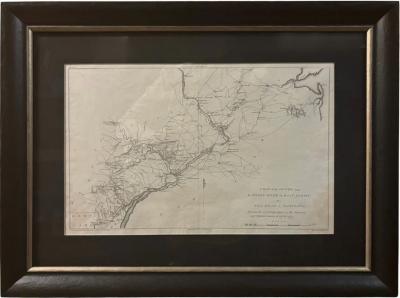
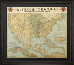
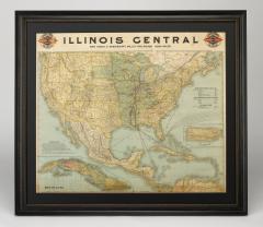
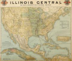
1899 Poole Brothers Railroad Map of the Illinois Central Railroad
-
Description
This is an 1899 railroad map of the Illinois Central and Yazoo and Mississippi Valley Railroads, published by the Poole Brothers. The map focuses on the continuous United States from the Atlantic to the Pacific Oceans, the Gulf of Mexico, and the Antilles. Remarkably detailed, the rail routes of the Illinois Central Railroad are marked in red, with each stop labeled. Major stops are overprinted in red, bold letters, with the short rail distances to New York listed above the stop and short rail distances to New Orleans listed below the name.
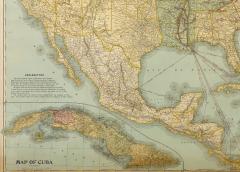
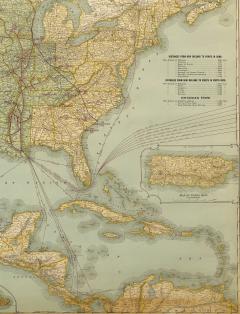
In addition to the Illinois Central network, numerous different rail lines are illustrated and the company running that line is noted along with many stops along each route. Sea routes from New Orleans to locations in Central America, the Caribbean, and Europe are marked and labeled with destination and distance, along with routes originating from Havana. Inset at bottom left is a map of Cuba; an inset map of Puerto Rico is included along the right border. An “Explanatory” text block is at left margin, which discusses the expansion of the Central Mississippi Valley route.
The Yazoo and Mississippi Valley Railroad was incorporated in 1882 as part of the Illinois Central Railroad. The original line ran from Jackson, Mississippi to Yazoo City, Mississippi. It later expanded through the Mississippi valley to Memphis, Tennessee. Several acquisitions in the following years, including the Mississippi and Tennessee Railroad, steadily increased the miles of track owned by the Illinois Central and lead to the creation of the Louisville, New Orleans, and Texas Railway.
This map was first produced by Poole Brothers in 1897. It was reissued again in 1899, as seen here. Based in Chicago, the Poole Brothers were active in the late 19th and early 20th century, with a primary publishing focus of railroad and travel maps.
In 1868, George Amos Poole along with his uncle William H. Rand and Andrew McNally formed a partnership that purchased the printing plant of the Chicago Tribune. This partnership later incorporated under the name Rand, McNally & Co. with George serving as its treasurer. George then left the Rand McNally organization to form Poole Brothers with his brother William H. Poole. Poole Brothers was a direct competitor to Rand McNally for the lucrative railroad business. Like many of its competitors, Poole Brothers maintained an office on Chicago's Printer's Row, located in the downtown Loop district. According to a 1918 issue of The Inland Printer, the firm was seriously engaged in “printing for transportation companies, with a patronage that included practically every railroad in the country." Poole Brothers later expanded to print periodicals, including Advertising Age and the New England Journal of Medicine.
CONDITION:
Map is in good condition, with original color. Minor stains along the bottom margin. Loss along top border due to old tape removal. Patched holes and reinforced and repaired tears on verso along the top four inches. Blank on verso.
Map has been archivally and artfully presented with a dark acid-free top mat and a custom-built black and brushed gold beaded frame. Framed dimensions: 41"H x 47"W x 1 1/4" D.
Accompanied by our company's letter of authenticity. - More Information
- Dimensions
Message from Seller:
Established in 2010, The Great Republic specializes in one-of-a-kind collectibles that honor American history, with a special focus on the rare and unique. Our collection is complete with rarities that are sure to wow, such as first edition books, antique hand-sewn flags from the Civil War, vintage travel posters, and original signatures from American presidents, such as George Washington and Abraham Lincoln, just to name a few. P: 719.471.6157 E: headquarters@great-republic.com