


Offered by:
The Great Republic
1 Lake Circle
Colorado Springs, CO 80906 , United States
Call Seller
719.471.6157
Showrooms
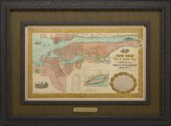
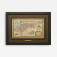
1855 "New-York City & County Map with Vicinity" Map by Charles Magnus
-
Description
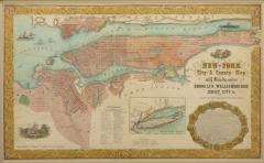
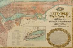
This is a beautiful hand-colored map titled “New York City & County Map with Vicinity entire Brooklyn, Williamsburgh, Jersey City &c.” The work was published in 1855 by Charles Magnus and is presented in a wooden archival frame.
Published by one of the best known and most prosperous printers in the mid to late 19th century, this map is wonderfully detailed. Turned clockwise so that cardinal west is at the top of the map, this is an unusual and attractive depiction of the city. The map shows the entirety of Manhattan as well as nearby neighborhoods. The map lends special attention to individual streets, blocks, parks and even important buildings. Magnus shows important ferry crossings, canals, and railroads as well with steamships navigating the Hudson River.
Centered on Manhattan, the map identifies additional districts including Manhattanville, Yorkville, and Harlem. Several areas have changed since the 1855 map was completed and some of the planned landfill is visible around Hoboken and Jersey City. Other sites have notably changed such as New York Lunatic Asylum that is in place of the modern site of Columbia University. At the bottom center of the map an alphanumerically keyed legend notes 'Universities, Colleges and Scientific and Literary, Benevolent-Institutions,' 'Public Buildings' and 'Places of Amusement.' An illustration of the New York City Hall adorns the bottom left of the map and is balanced by the full text of the Declaration of Independence surrounded by an elaborate medallion at the bottom right. The map is beautifully decorated with acanthus leaf motif border. Overall, this map is an appealing example of Magnus' printing and New York City in the mid-19th century.
CONDITION:
Overall good condition. The map has some foxing throughout from age and mild color loss. One crease runs down the middle of the once-folded map. Otherwise, the colors are still vibrant and the map is free of any tears. A publisher's mark, Charles Magnus 12, is visible at the bottom left corner as well as directly underneath the text of the Declaration of Independence. The map is framed according to archival standards and sits behind UV protective glass.
Framed dimensions: 36” H x 49” W x 2.5” D.
Accompanied by our company's letter of authenticity. - More Information
- Dimensions
Message from Seller:
Established in 2010, The Great Republic specializes in one-of-a-kind collectibles that honor American history, with a special focus on the rare and unique. Our collection is complete with rarities that are sure to wow, such as first edition books, antique hand-sewn flags from the Civil War, vintage travel posters, and original signatures from American presidents, such as George Washington and Abraham Lincoln, just to name a few. P: 719.471.6157 E: headquarters@great-republic.com