Promoting America: Maps of the Colonies and the New Republic
 |
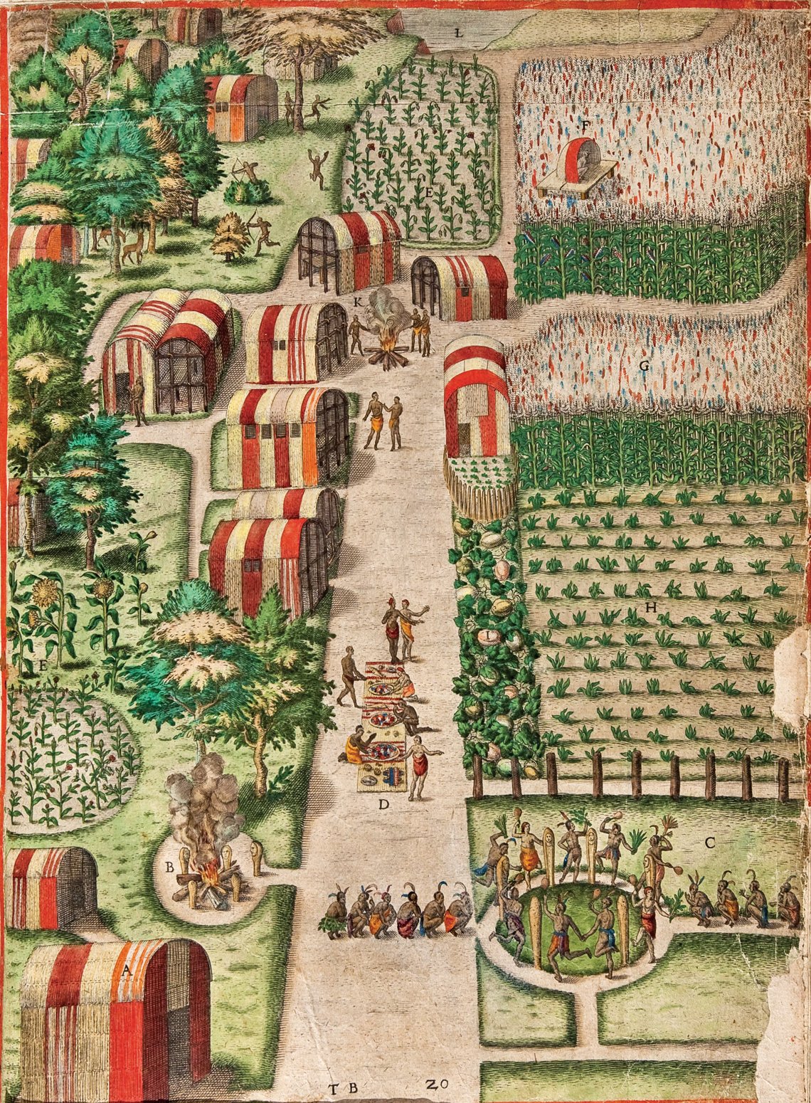 | |
Fig. 1: The Town of Secota from A Briefe and True Report of the New Found Land of Virginia (trans.), Plate XX, Theodore De Bry, engraver and publisher; after watercolors by John White Frankfurt, Germany, 1590. Line engraving on laid paper with hand-coloring. Gift of Mr. and Mrs. Richard F. Barry, III, Mr. and Mrs. Macon F. Brock, Mr. and Mrs. David R. Goode, Mr. and Mrs. Conrad M. Hall, Mr. and Mrs. Thomas G. Johnson, Jr., Mr. and Mrs. Charles W. Moorman, IV, and Mr. and Mrs. Richard D. Roberts (2017–194). |
From England’s first attempts to colonize America, artists and mapmakers created impressions of the New World that fueled the European imagination. Maps, in particular, served as powerful propaganda tools for colonial expansionists eager to convey the richness and abundance of the land and its inhabitants. Mapmakers often incorporated iconographic imagery of America’s flora, fauna, and native population within the decorative elements on their maps to promote the promise of a good and prosperous life in the New Worl
One of the first attempts to promote colonization in America was through the drawings of John White (ca. 1539–ca. 1593), who painted detailed watercolors of plants and animals, as well as portraits of the Algonquin Indians they met during a reconnaissance voyage to establish a settlement at Roanoke in 1585. Many of White’s drawings and the prints that were subsequently engraved from them depict an Anglicized vision of the New World. They subtly show how Europeans shaped their view of America in a way that conformed to their own cultural conventions and allowed them to advance their promotional aspirations. For example, White illustrated the Algonquian town of Secota as an orderly place with well laid-out fields of corn, tobacco, squash, and sunflowers planted in rows and segregated from one another (Fig. 1). Agricultural archaeology has since shown that the American Indian approach to the land differed substantially from the manicured nature of English landscape practices. By illustrating the town of Secota in this European manner, the artist and engraver were projecting a sense of familiarity upon an unfamiliar environment to entice prospective settlers.
Captain Arthur Barlowe (1550–1620), who accompanied White to Roanoke, described their initial encounter with the Algonquins:
We were entertained with all love, and kindness, and with as much bounty, after their manner, as they could possibly devise. We found these people most gentle, loving, and faithful, void of all guile, and treason, and such as lived after the manner of the golden age. The earth bringeth forth all things in abundance, as in the first creation, without toil or labor.
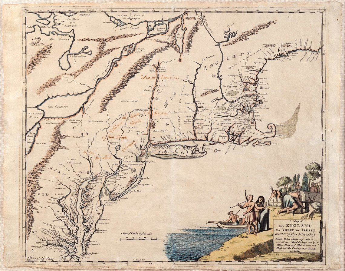 |
Fig. 2: A Map of New ENGLAND New YORKE New JERSEY MARY-LAND & VIRGINIA, Robert Morden and William Berry, publishers, London, England, 1676. Line engraving on laid paper with hand-coloring and manuscript notations. Courtesy of Michael and Carolyn McNamara. |
In characterizing their environment as “in the first creation,” Barlowe equated the region and its inhabitants to the Garden of Eden. The overall impression was one of a biblical paradise where people could thrive with minimal effort.
While a number of seventeenth-century promotional works equated the abundance of the New World to that of the Garden of Eden, the manuscript notations added to Robert Morden (ca.1650–1703) and William Berry’s (1639–1718) Map of New ENGLAND New YORKE New JERSEY MARY-LAND & VIRGINIA sometime during the seventeenth or eighteenth century suggest the owner’s attempt to document the actual location of Eden according to the description in Genesis 2: 10-14 (Fig. 2):
And a river went out of Eden to water the garden: and from thence it was parted, and became into four heads. The name of the first is Pison: that is it which compasseth the whole land of Havilah, where there is gold; And the gold of that land is good: there is bdellium and the onyx stone. And the name of the second river is Gihon: the same is that compasseth the whole land of Ethiopia. And the name of the third river is Hiddekel: that is it which goeth toward the east of Assyria. And the fourth river is Euphrates.
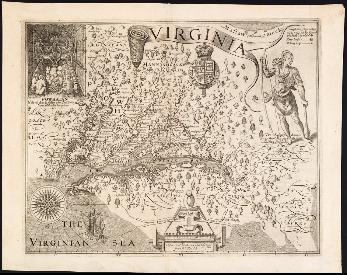 |
Fig. 3: VIRGINIA, Captain John Smith, cartographer; William Hole, engraver, Oxford, England, 1612. Line engraving on laid paper. Gift of Mr. and Mrs. Richard F. Barry, III, Mr. and Mrs. Macon F. Brock, Mr. and Mrs. David R. Goode, Mr. and Mrs. Conrad M. Hall, Mr. and Mrs. Thomas G. Johnson, Jr., Mr. and Mrs. Charles W. Moorman, IV, and Mr. and Mrs. Richard D. Roberts (2017–197). |
Relying on the biblical description of the Garden of Eden, the owner of this map reaffirmed the notion that America’s abundant natural resources equated to those described in the Bible and determined that the true location of the Garden was in the present-day state of New York.
Most of the promotional graphics generated during the seventeenth century were produced as maps, rather than prints or watercolors. In addition to being extraordinarily useful documents, maps also conveyed a host of unique and important messages. Only shortly after arriving in Jamestown in 1607, Captain John Smith (1580–1631) set out to explore the Chesapeake. He covered approximately three thousand miles, sailing up and down the tributaries of the Bay in an open barge. The local Indigenous population were helpful to Smith, providing him information on the geography, and he meticulously acknowledged their presence in Virginia by locating 166 of their villages on his map. Additionally, on one side of the map a large amount of space was used to illustrate a Susquehanna Indian, and on the other a scene of paramount chief Powhatan and his warriors (Fig. 3).
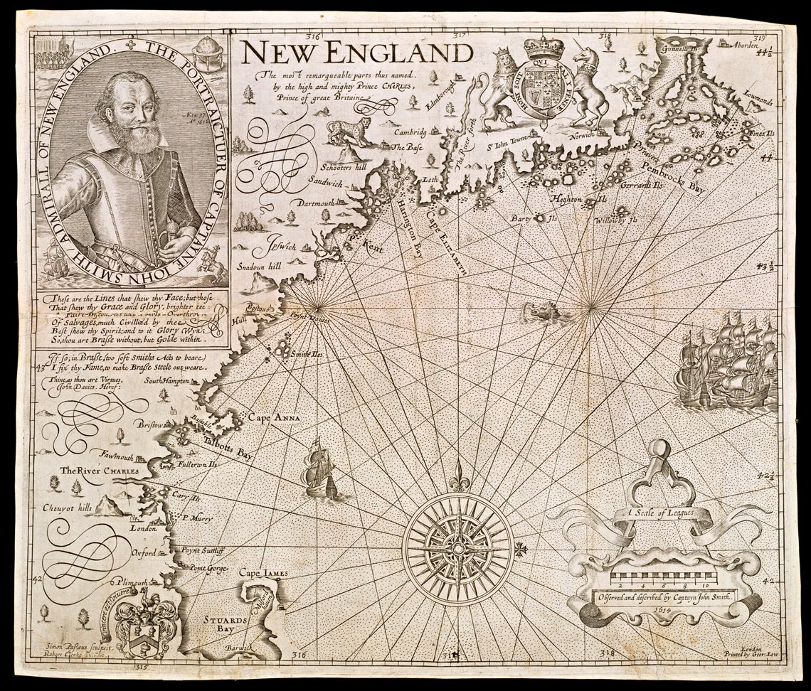 |
Fig. 4: NEW ENGLAND, Captain John Smith, cartographer; William Hole, engraver, London, England, 1624 (originally published in 1616). Line engraving on laid paper. Museum purchase (1972–37). |
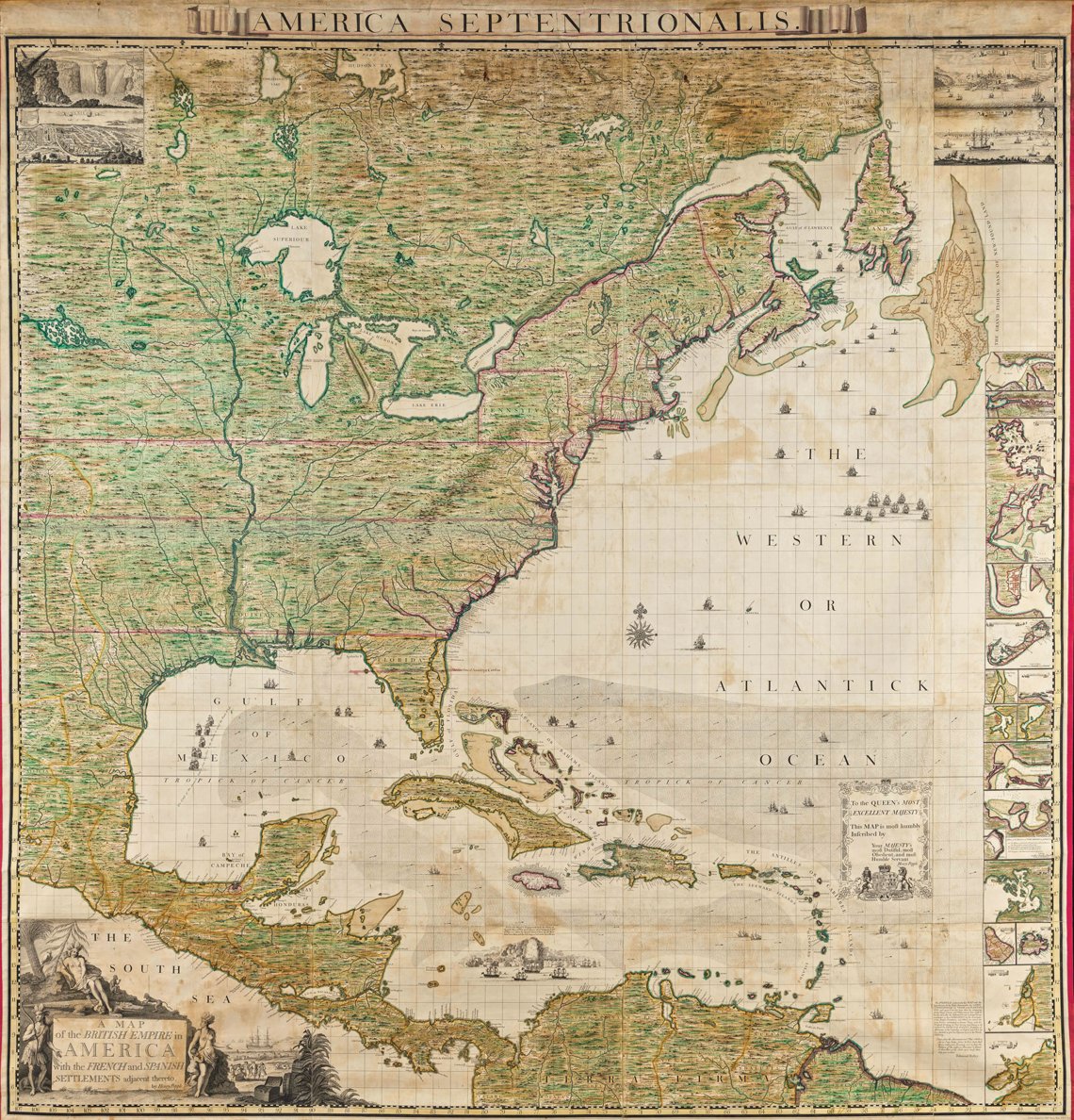 |
Fig. 5: A MAP of the BRITISH EMPIRE in AMERICA with the FRENCH and SPANISH SETTLEMENTS adjacent thereto, Henry Popple, cartographer; Bernard Baron, William Henry Toms, and Richard William Seale, engravers, London, England, 1733. Line engraving on laid paper with hand-coloring; pasted to linen and attached to a roller and ledge. Museum purchase (1955-408). |
Six years later, Smith charted the New England coastline, returning to England with valuable geographic information and great enthusiasm for establishing a colony at Plymouth. The nomenclature and decoration of his New England map reveal a different attitude towards America than that conveyed in his map of Virginia. In the seven years between Smith’s exploration of Virginia and his charting of the New England coast, England’s interest had shifted from one of “discovery” and “exploration,” to one of establishing settlements and claiming land. Unlike the Virginia map, there are no Native American sites identified on the New England map, which is instead labeled with recognizable English names. Likewise, the illustrations of Indians on the Virginia map were supplanted with Smith’s impressively large self-portrait (Fig. 4).
Mapmakers had other devices at their disposal to convey subtle messages. In 1733, Henry Popple (16??–1743) issued A MAP of the BRITISH EMPIRE in AMERICA, which measures an impressive eight by eight feet when its twenty separate sheets are assembled (Fig. 5). The sheer size of the map suggested England’s dominant role in America. It was the largest printed map of any part of North America made before the American Revolution. Other features of Popple’s map reveal the motivation behind its production. The title appears to be etched onto a stone tablet upon which British holdings were identified as part of her “EMPIRE,” but French and Spanish holdings were described as “SETTLEMENTS.” The generic portrayal of an American Indian on the left of the decorative cartouche points to the title as if to confirm the assertion that the area represented belonged to Britain, while the figure on the right points to the thriving commercial activity along the shore. At the pinnacle of the cartouche design is an allegorical representation of America.
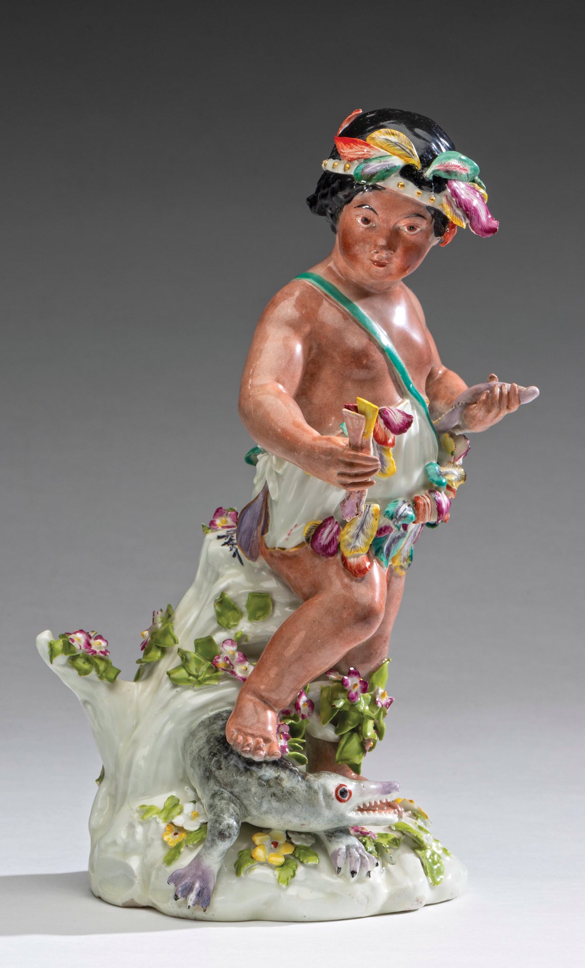 | 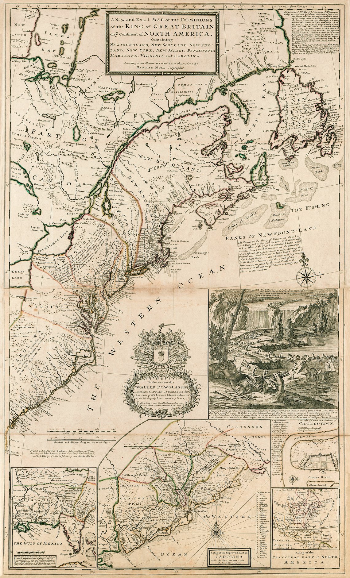 | |
Left: Fig.6: America, Derby, England, 1765-1775. Soft-paste porcelain. Museum purchase (1936–742). Right: Fig. 7: A New and Exact MAP of the DOMINIONS of the KING of GREAT BRITAIN on ye Continent of NORTH AMERICA, Herman Moll, cartographer and engraver, Thomas and John Bowles, publishers, London, England, after 1735 (originally published in 1715). Line engraving on laid paper with hand-coloring. Museum purchase (1968–130). | ||
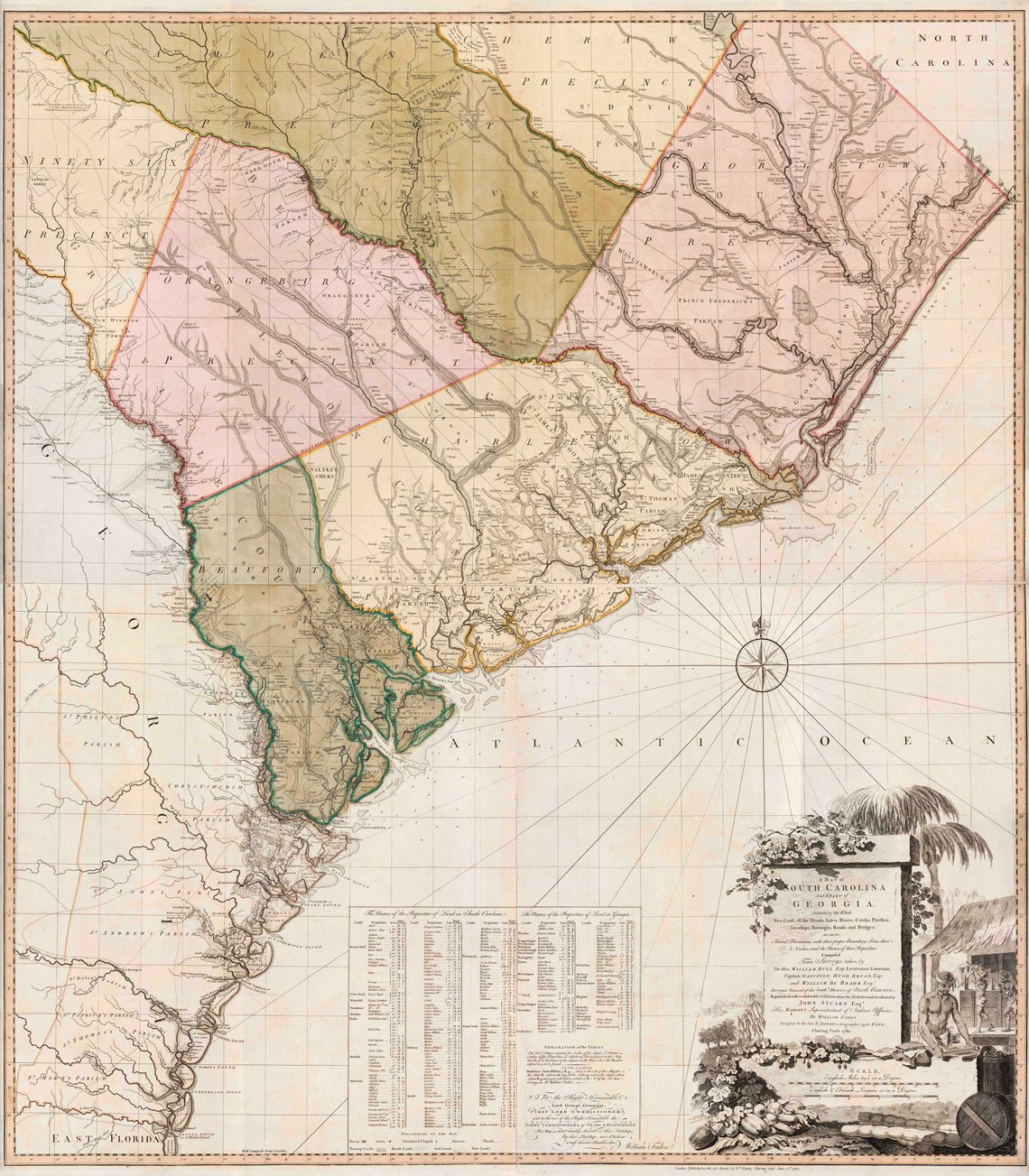 | |
Fig. 8: A Map Of SOUTH CAROLINA And a PART of GEORGIA, William Gerard De Brahm and John Stuart, cartographers; Thomas Jefferys and William Faden, engravers; William Faden, publisher, London, England, 1780. Line engraving on laid paper with hand coloring. Museum purchase (2019–49). |
Allegorical representations of the four known continents became popular during the latter decades of the seventeenth century. America was typically characterized by a partially clothed Indian with a feathered headdress, usually seated upon, or with one foot resting on, an armadillo or an alligator. The Derby porcelain figure of America (part of a set of four), on view in the exhibition, assumes a pose similar to that depicted in the cartouche of Popple’s ambitious MAP of the BRITISH EMPIRE in AMERICA (Fig. 6).
The abundance of America’s natural resources was often conveyed through the decoration on maps to reflect the economic potential for prospective English/European settlers. The mapmaker’s depiction of the Industry of ye Beavers, illustrated in an inset on Herman Moll’s (1654?–1732) A New and Exact MAP of the DOMINIONS of the KING of GREAT BRITAIN, associates the industriousness of one of these resources with economic opportunity in America (Fig. 7). From the beginning of the seventeenth century, beaver pelts provided a primary commodity for trade and served as a main source of competition between the French and the English in America. Since industry was known to produce wealth, the industrious beavers represented the success that could be achieved in America with, as Moll described on his map, “great order and wonderfull [sic] Dexterity.” This scene also depicts an early view of Niagara Falls. These falls would eventually become an iconic symbol representing pride in what was perceived as America’s vast and untamed wilderness.
 | |
Fig. 9: Flora Virginica Exhibens Plantas, Johannes Fredericus Gronovius after John Clayton, Leiden, Holland, 1762. Line engraving and letterpress on laid paper. Gift of Mr. and Mrs. Richard F. Barry, III, Mr. and Mrs. Macon F. Brock, Mr. and Mrs. David R. Goode, Mr. and Mrs. Conrad M. Hall, Mr. and Mrs. Thomas G. Johnson, Jr., Mr. and Mrs. Charles W. Moorman, IV, and Mr. and Mrs. Richard D. Roberts (2017–217). |
After the conclusion of the French and Indian War in 1763, Britain turned to cartography to take stock of its empire in North America. One such map intended to record the Crown’s colonial ambitions in North America was William De Brahm’s (1718–ca. 1799) map of South Carolina and Georgia, originally published in 1757 (Fig. 8). Twenty-three years later, that map was updated to represent how far English settlement had spread to the Backcountry as a result of negotiations, treaties, and wars with the Cherokee and the French. The decorative cartouche emphasizes the South Carolina colony’s profitable trade in indigo. That scene illustrates the work of processing indigo into dye cubes and packing them for shipment. The principal feature, however, is an imposing tablet on which England’s claims were essentially etched in stone. The large size of the monument suggests dominance, and the fact that vegetation has already begun to grow around it suggests longevity and permanence. There are no Englishmen depicted—only the enslaved, whose presence is secondary to the imposing stone edifice.
America provided a vast, boundless field of study for the transatlantic scientific community. Naturalists became preoccupied with identifying and cataloging nature. Virginia colonists, in particular, played a pivotal role in contributing to this exchange of information and specimens. By the 1730s, Gloucester County, Virginia, botanist John Clayton (1694/5–1773) provided naturalists such as Mark Catesby (1683–1749) in England and Johannes Fredericus Gronovius (1690–1762) in Holland, with over five hundred seed and plant specimens. In 1762, Gronovius arranged Clayton’s work in Linnaean order, and published it under the title Flora Virginica. The accompanying map identifies the location where fifty-seven of his specimens were gathered, and is perhaps the earliest botanical map of any location in the world (Fig. 9).
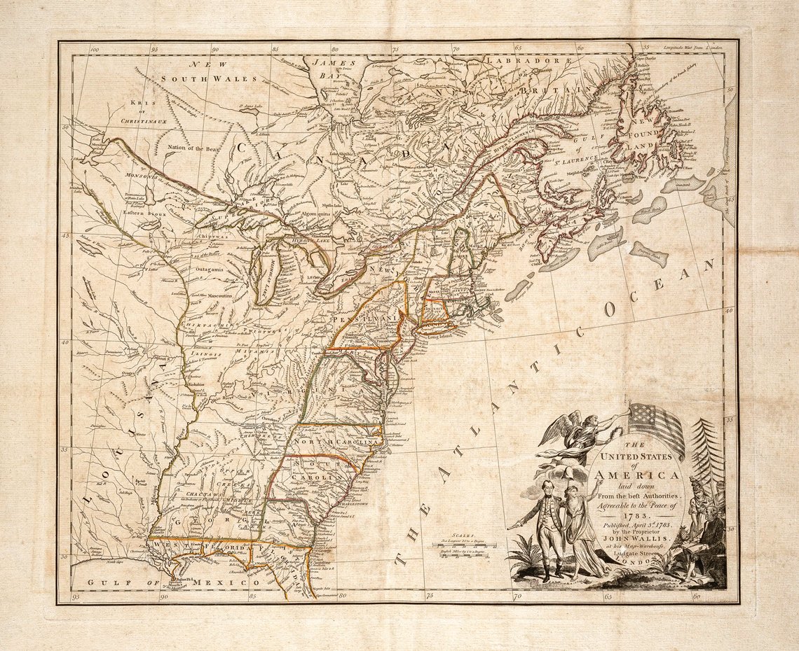 |
Fig. 10: THE UNITED STATES of AMERICA laid down From the best Authorities, John Wallis, cartographer and publisher after work by Jean-Baptiste Bourguignon d’Anville, London, England, 1783. Line engraving on laid paper with hand-coloring. Museum purchase (1975–128). |
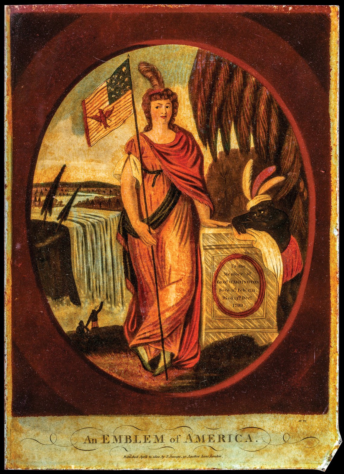 | |
Fig. 11: An Emblem of America, P. Stampa, publisher, London, England, 1800. Mezzotint engraving with hand coloring on glass. Museum Purchase (1930–462). |
The American Revolution compelled former colonists to reimagine how their newly formed nation would be viewed by the world. While the geography depicted on John Wallis’s map of the United States had been known for almost four decades, the decorative cartouche is noteworthy for symbolizing the new concept of America as envisioned by the founders (Fig. 10) The allegorical scene replaces traditional imagery of “America” with symbols that celebrate independence from Great Britain. The cartouche features George Washington (left) alongside Liberty, while Benjamin Franklin (right), supported by Justice and Minerva (the Roman goddess of wisdom and war), write the Treaty of Paris. This map was published in the spring of 1783 while British and American diplomats—including Franklin—were still finalizing the details of the Treaty of Paris, which defined the United States’ geographic borders and required Great Britain to recognize the new nation as “free sovereign and Independent States.”
With independence, the allegorical figure symbolizing “America,” devised in the sixteenth century, was transformed to represent the newly formed United States. Increasingly, representations of Indians were replaced by a white woman, reminiscent of allegorical figures from Ancient Rome and Greece, as shown in An Emblem of America (Fig 11). Representations of Indians or the enslaved did not disappear, they were transformed. Depicted leaning on a monument to Washington, a Black child, dressed as a generic representation of a native figure, enforces the viewpoint that Indians and those of African descent remained unequal in the new nation.
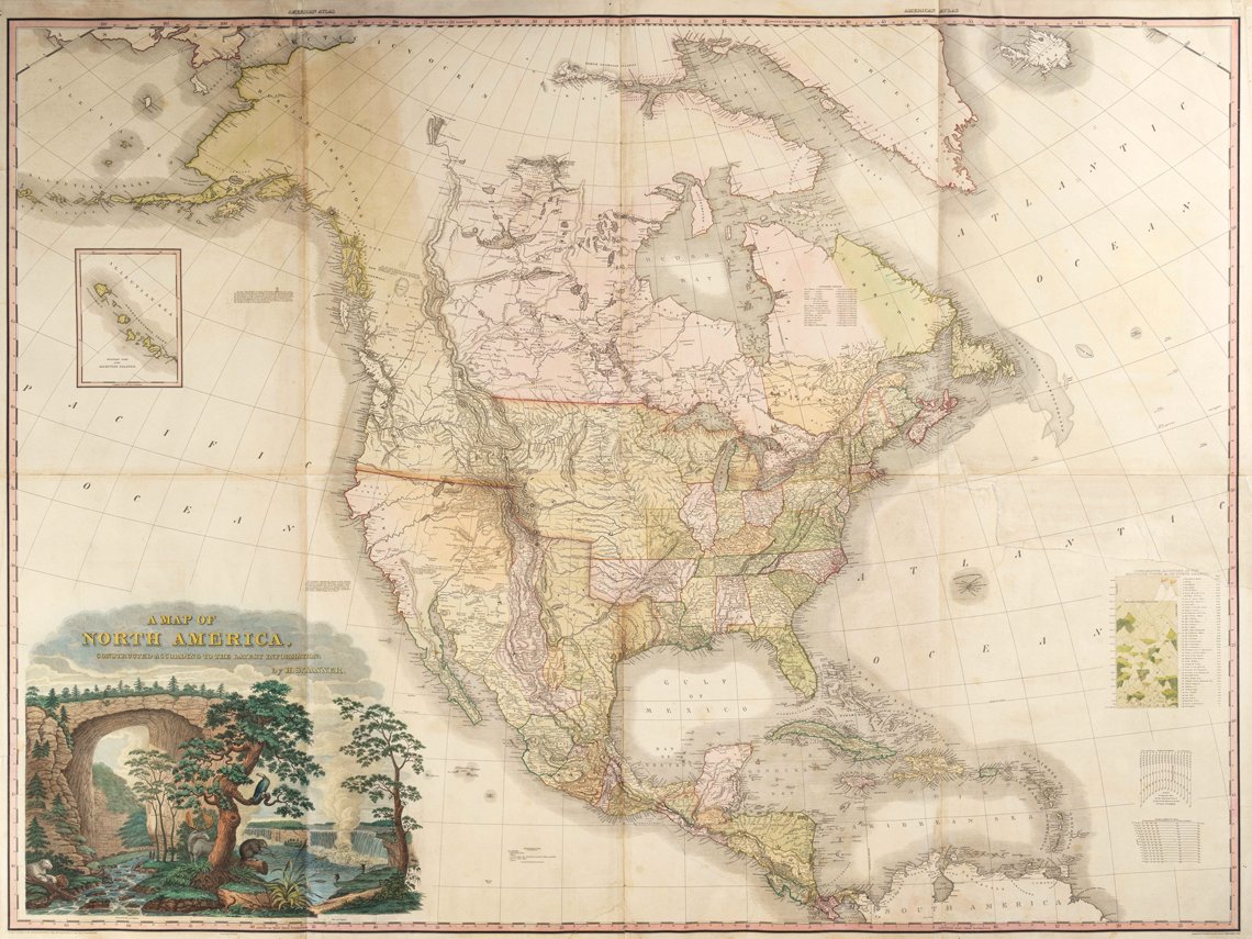 |
Fig. 12: A MAP OF NORTH AMERICA, Henry Schenck Tanner, cartographer, engraver and publisher, Philadelphia, PA, 1822. Line engraving on laid paper with hand-coloring. Museum purchase (1997–5). |
 | |
Fig. 12a: Detail of figure 12. |
By the first decades of the nineteenth century, Americans began to regard natural wonders as symbols of their national pride. The cartouche on Henry Schenck Tanner’s (1786–1858) A Map of North America combined images of both Niagara Falls and Natural Bridge along with other symbolic forms of American fauna, such as a rattlesnake, a beaver, and an eagle (Figs. 12, 12a). Thomas Jefferson and James Madison, among others, believed that the success of the new nation was tied to the exploration and cultivation of the frontier. Following the purchase of the Louisiana Territory in 1803, Jefferson commissioned Meriwether Lewis (1774–1809) and William Clark (1770–1838) to map the region and find a route across the continent. Their expedition opened the door to others and helped establish the United States presence in the West. Tanner incorporated information from discoveries made by Lewis and Clark (1804–1806), Zebulon Pike (1806), and Stephen H. Long (1819–1820), to create the most significant map of the American West produced during the first decades of the nineteenth century.
The exhibition Promoting America: Maps of the Colonies and the New Republic, is on view through March 27, 2022 at the DeWitt Wallace Decorative Arts Museum, one of the Art Museums of Colonial Williamsburg. Tickets are available at colonialwilliamsburg.org or by calling 855.296.6627.
Margaret Beck Pritchard is Deputy Chief Curator, and Katie McKinney is the Margaret Beck Pritchard Assistant Curator of Maps & Prints at The Colonial Williamsburg Foundation, Williamsburg, Virginia.
All images courtesy of The Art Museums of Colonial Williamsburg.
This article was originally published in the 21st Anniversary/Spring 2021 issue of Antiques & Fine Art magazine, a fully digitized version of which is available at www.afamag.com. AFA is affiliated with Incollect.com.
 |